Across America on a
Motor Bicycle - 1903
B Y G E O R G E A . W Y M A N
Preface (About the Story)
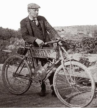
In 1903 a young gentleman from San Francisco by the Name of George A. Wyman rode, pushed, pulled, carried, and crawled his 1902 "California" brand motor bicycle from San Francisco to New York City. He achieved this monumental undertaking before the first automobile crossing by Dr. Horatio Nelson Jackson (in his Winton Automobile) and made better time, finishing his adventure in New York City at the "New York Motorcycle Club" rooms, 1904 Broadway, a mere 50 days after departing San Francisco. Amazingly, over half of Mr. Wyman's journey was accomplished by pounding over the ties of the trans-continental railroad as there were no "real" roads in the sense that we, in the modern age, have come to think of for Mr. Wyman to travel upon.
Patented and manufactured by Roy C. Marks, the 'California' motor bicycle was produced from 1901 through 1904; in 1904 this company was sold to "Consolidated Manufacturing" of Toledo, Ohio and became the "Yale" motorcycle. 1904 and 1905 were the only years for the "Yale California" ('Yale' make- 'California' model). 1903, the year of Mr. Wyman's coast-to-coast journey, was a landmark year filled with "first" accomplishments. The first "Harley-Davison" motorcycle was produced, the first year of Henry Ford's famous automobile company; as previously mentioned this was the year of the first automobile crossing of the U.S., the year the first Tour De France bicycle race was run, and the first flight of the Wright Brothers airplan- just to name a few.
George A. Wyman's account was originally published in a series of articles, in
his own words, in "The Motorcycle"; a periodical of the time dedicated to
motorcycling. "The Motorcycle" was a relatively short-lived periodical, in
publication from 1903 until 1906, and yet played a key role in the history of
motorcycling. George A. Wyman's incredible account was in their premier issue
(Issue 1, Volume1, June 1903).
Unfortunately, this accomplishment was for the most part lost and forgotten. George A. Wyman never received the credit he was due for this historic feat. This series of articles was found and reprinted in a special edition of "Road Rider" magazine (courtesy of the late Roger Hull) in it's complete form in the late 1970's (1979). Yet again it was lost and forgotten until published, in installments, in “The Antique Motorcycle” a publication of the Antique Motorcycle Club of America. Still Mr. Wyman and his accomplishment remained somewhat obscure.
Born in 1877, in California, George A. Wyman at age 25, who was a member of the
Bay City Wheelmen and a bicycle racer, became the first person to cross the
Sierra Nevada Mountains with a motor vehicle in 1902; riding his 1 1/2
horsepower California brand motor bicycle to Reno, Nevada for a bicycle-racing
event at the Reno Fairgrounds. George arrived on August 31st, 1902 awaiting the
arrival of his comrades who brought his racing cycle along by rail one week
later for the big race, against rival cyclists the Reno Wheelmen, on Sept. 7,
1902.
It was this trip to Reno that gave Mr. Wyman the inspiration to attempt the
first crossing of the American continent on his motor bicycle.
To quote George (from his original 1903 text) while he was traveling over the
Sierra mountains: "I was traveling familiar ground. During the previous summer I
had made the journey on a California motor bicycle to Reno, Nevada, and knew
that crossing the Sierras, even when helped by a motor, was not exactly a path
of roses. But it was that tour, nevertheless, that fired me with the desire to
attempt this longer journey - to become the first motorcyclist to ride from
ocean to ocean."
George A. Wyman left the corner of Market and Kearney streets in San Francisco,
CA at 2:30 P.M on May 16, 1903 and arrived in New York City on July 6, 1903;
enduring many hardships and heartbreaks while en route, yet he still manages to
tell his story with a great grace, humility, and wit that could only be
described as true American spirit.
George did in fact become the first motorcyclist to cross this great land of
ours, he then disappeared into obscurity receiving no credit in the pages of our
history books for his accomplishment. He also seemed to have just disappeared;
we have been doing genealogical research (along with all of the other research
concerning the vehicle, the geography of the time, the route traveled, etc.) and
have only recently had a breakthrough with the rest of his story. Fortunately,
we have been able to discover a little bit about what happened to George A.
Wyman after his continental crossing. Here is what we have discovered: It would
appear that George continued to follow his interest in motor vehicles as he
worked in different capacities relating to motor vehicles.
According to the 1910 census George had returned to San Francisco where he was
working as a mechanic and chauffer, while residing at the Dorel Hotel, 1507
California Street. The 1920 census tells us that George, at age 43, was at this
time married with three children, and was working as a second hand automobile
dealer / salesman. His wife Nellie Wyman, (maiden name Lovern) age 41, had
brought a child into the union; her son Harold, age 19, was a clerk for the
Railroad. George and Nellie had also conceived two children of their own- son
William (Billy), age 4; and son Richard, age 2. George A. Wyman had relocated
from San Francisco by this time. He and his family apparently were now residing
in Eureka, California. In the 1930 Census, George is still living in Eureka, CA
with his two sons William and Richard. George is now working as an automobile
mechanic. There is no record of his wife Nellie residing with him at this point.
Through a search of the Social Security Death Index we discovered that George A.
Wyman, the first motorcyclist to cross the Continental United States, left this
world November 15, 1959 at age 82 in San Joaquin county, CA.
Across America on a
Motor Bicycle - 1903
B Y G E O R G E A . W Y M A N
Part I. Over The Sierras And Through The Snow Sheds
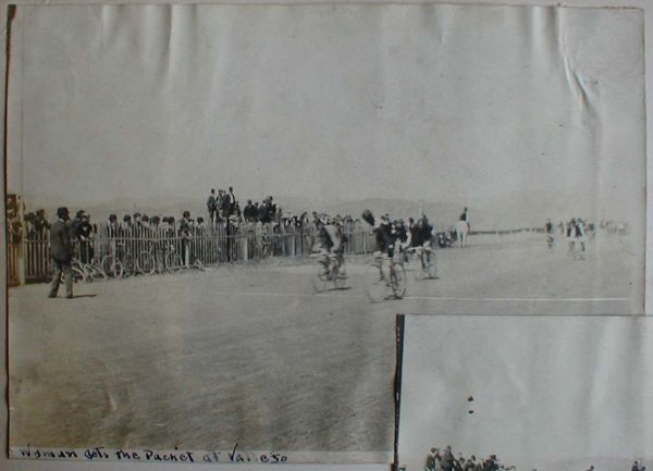
Little more than three miles constituted the first day's travel of my journey
across the American continent. It is just three miles from the corner of Market
and Kearney streets, San Francisco, to the boat that steams to Vailejo,
California, and, leaving the corner formed by those streets at 2:30 o'clock on
the bright afternoon of May 16, less than two hours later I had passed through
the Golden Gate and was in Vallejo and aboard the "Ark," or houseboat
of my friends, Mr. and Mrs. Brerton, which was anchored there. I slept aboard
the "Ark" that night. At 7:20
o'clock the next morning I said goodbye to my hospitable hosts and to the
Pacific, and turned my face toward the ocean that laps the further shore of
America. I at once began to go up in the world. I knew I would go higher; also
I knew my mount. I was traveling familiar ground. During the previous summer I
had made the journey on a California motor bicycle to Reno, Nevada, and knew
that crossing the Sierras, even when helped by a motor, was not exactly a path
of roses. But it was that tour, nevertheless, that fired me with desire to
attempt this longer journey - to become the first motorcyclist to ride from
ocean to ocean.
For thirteen miles out of Vallejo the road was a succession of land waves; one
steep hill succeeded by another, but the motor was working like clockwork and
covered the distance in but a few moments over the hour, and in the face of a
wind the force ot which was constantly increasing. The further I went the
harder blew the wind. Finally it actually blew the motor to a standstill~ I
promptly dismounted and broke off the muffler. The added power proved equal to
the emergency, and the wind ceased to worry. My next dismount was rather
sudden. While going well and with no thought of the road I ran full tilt into a
patch of sand. I landed ungracefully, but unharmed, ten feet away. The fall,
however broke my cyclometer and also cracked the glass of the oil cup in the
motor - damage which the plentiful use of tire tape at least temporarily
repaired. Entering the splendid farming country of the Sacramento Valley, it is
easy to imagine this the garden spot of the world. Magnificent farms, well-kept
vineyards and a profusion of peach, pear, and almond orchards line the road;
and that scene so common to Californians' eyes and so odd to visitors'- great
gangs of pigtailed Chinese at work with the rake and hoe - is everywhere
observable.
At Davisville, 59 miles from Vallejo, those always genial and well meaning
prevaricators, the natives, informed me that the road to Sacramento, which
point I had set as the day's destination, was in good shape: and though I knew
that in many places the Sacramento River, swollen by the melting snow of the
Sierras, had, as is the case each year, overflowed its banks. I trustingly
believed them. Alas! for human faith. Eight miles from Davisville the road lost
itself in the overflowing river. The water was too deep to navigate on a motor
bicycle or any other bicycle, so I faced about and retraced the road for four
miles, or until I reached the railroad tracks.
The river and its tributaries, and for several miles the lowlands, are spanned
by trestlework, on which the rails are laid. The crossties of the roadbed
proper are not laid with punctilious exactitude, nor are the intervaling spaces
leveled or smoothed. They make uncomfortable and wearying walking: they make
bicycle riding of any sort dangerous when it is not absolutely impossible. On
the trestles themselves the ties are laid sufficiently close together to make
them ride-able – rather "choppy" riding, it is true, but much faster
and less tiresome than trundling. I walked the road-bed; I "bumped
it" across the trestles and
that night, the 17th, I slept in Sacramento, a day's journey of 82 miles and
slept soundly.
It was late when I awoke, and almost noon when I left the beautiful capital of
the Golden State. The Sierras and a desolate country were ahead, and I made
preparations accordingly. Sacramento's but 15 feet above sea level; the summit
of the range is 7,015 feet.
Three and a half miles east of Sacramento the high trestle bridge spanning the
main stream of the American River has to be crossed, and from this bridge is
obtained a magnificent view of the snow-capped Sierras, "the great barrier
that separates the fertile valleys and glorious climate of California from the
bleak and barren sagebrush plains, rugged mountains, and forbidding wastes of
sand and alkali that, from the summit of the Sierras, stretch away to the
eastward for over a thousand miles." The view from the American River bridge is
imposing, encompassing the whole foothill country, which "rolls in broken,
irregular billows of forest crowned hill and charming vale, upward and onward
to the east; gradually growing more rugged, rocky, and immense, the hills
changing to mountains, the vales to canyons until they terminate in bald, hoary
peaks whose white, rugged pinnacles seem to penetrate the sky, and stand out in
ghostly, shadowy outline against the azure depths of space beyond."
A few miles from Sacramento is the land of sheep. The country for miles around
is a country of splendid sheep ranches, and the woolly animals and the
sombrero-ed ranchmen are everywhere. Speeding around a bend in the road I came
almost precipitately upon an immense drove which was being driven to Nevada.
While the herders swore, the sheep scurried in every direction, fairly piling
on top of each other in their eagerness to get out of my path. The timid,
bleating creatures even wedged solidly in places. As they were headed in the
same direction I was going, it took some time to worry through the drove.
The pastoral aspect of the sheep country gradually gave way to a more rugged
landscape, huge boulders dotting the earth and suggesting the approach to the
Sierras. At Rocklin the lower foothills are encountered: the stone beneath the
surface of the ground makes a firm roadbed and affords stretches of excellent
goings. Beyond the foothills the country is rough and steep and stony and
redolent of the days of '49. It was here and hereabouts that the gold finds
were made and where the rush and "gold fever" were fiercest.
Desolation now rules, and only heaps of gravel, water ditches, and abandoned
shafts remain to give color to the marvelous narratives of the "oldest
inhabitants" that remain. The steep grades also remain, and the little
motor was compelled to work for its "mixture". It "chugged"
like a panting being up the mountains, and from Auburn to Colfax- 60 miles from
Sacramento-where I halted for the night, the help of the pedals was necessary.
When I left Colfax on the morning of May 19, the motor working
grandly, and though the going was up, up, up it carried me along without any
effort for nearly 10 miles. Then it overheated, and I had to "nurse"
it with oil every three or four miles. It recovered itself during luncheon at
Emigrants' Gap, and I prepared for the snow that had been in sight for hours
and that the atmosphere told me was not now far ahead. But between the Gap and
the snow there was six miles of the vilest road that mortal ever dignified by
the term. Then I struck the snow, and as promptly I hurried for the shelter of
the snow sheds, without which there would be no travel across continent by the
northern route. The snow lies 10, 15, and 20-feet deep on the mountain sides,
and ever and anon the deep boom or muffled thud of tremendous slides of
"the beautiful" as it pitches into the dark deep canyons or falls
with terrific force upon the sheds conveys the grimmest suggestions.
The sheds wind around the mountain sides, their roofs built aslant that the
avalanches of snow and rock hurled from above may glide harmlessly into the
chasm below. Stations, section houses, and all else pertaining to the railways
are, of course, built in the dripping and gloomy, but friendly, shelter of
these sheds, where daylight penetrates only at the short breaks where the
railway tracks span a deep gulch or ravine.
To ride a motor bicycle through the sheds is impossible. I walked, of course,
dragging my machine over the ties for 18 miles by cyclometer measurement. I was
7 hours in the sheds. It was 15 feet under the snow. That night I slept at Summit, 7,015 feet
above the sea, having ridden - or walked - 54 miles during the day. The next
day, May20, promised
more pleasure, or, rather, I fancied that it did so, l knew that I could go no
higher and with dark, damp, dismal snow sheds and the miles of wearying walking
behind me, and a long downgrade before me, my fancy had painted a pleasant
picture of, if not smooth, then easy sailing. When I sought my motor bicycle in
the morning the picture received its first blur. My can of lubricating oil was
missing. The magnificent view that the tip top the mountains afforded lost its
charms. I had eyes not even for Donner Lake, the "gem of the
Sierras," nestling like a great, lost diamond in its setting of fleecy
snow and tall, gaunt pines.
Oil such as I required was not to be had on the snowbound summit nor in the
untamed country ahead, and oil I must have - or walk, and walk far. I knew that
my supply was in its place just after emerging from the snow sheds the night
before, and I reckoned therefore that the now prized can had dropped off in the
snow, and I was determined to hunt for it. I
trudged back a mile and a half. Not an inch of ground or snow escaped search;
and when at last a dark object met my gaze I fairly bounded toward it. It was
my oil! I think I now know at least a thrill of the joy experienced by the
traveler on the desert who discovers an unsuspected pool.
The oil, however was not of immediate aid. It did not help me get through the
dark, damp, dismal tunnel, 1,700 feet long, that afforded the only means of
egress from Summit. I walked through that, of course, and emerging, continued
to walk, or rather, I tried to walk. Where the road should have been was a wide
expanse of snow - deep snow. As there was nothing else to do, I plunged into it
and floundered, waded, walked, slipped, and slid to the head of Donner Lake. It
took me an hour to cover the short distance. At the Lake the road cleared and
to Truckee, 10 miles down the canyon, was in excellent condition for this
season of the year. The grade drops 2,400 feet in the 10 miles, and but for the
intelligent Truckee citizens I would have bidden good-bye to the Golden State
long before I finally did so.
The best and shortest road to Reno? The intelligent citizens, several of them
agreed on the route, and I followed their directions. The result: Nearly two
hours later and after riding 21 miles, I reached Bovo- six miles by rail from
Truckee. After that experience I asked no further information, but sought the
crossties, and although they shook me up not a little, I made fair time to
Verdi- 14 miles. Verdi is the first town in Nevada and about 40 miles from the
summit of the Sierras. Looking backward the snow-covered peaks are plainly
visible, but one is not many miles across the State line before he realizes
that California and Nevada, though they adjoin, are as unlike as regards soil,
topography, climate, and all else as two countries between which an ocean rolls.
Nevada is truly the "Sage Brush State." The scrubby plant marks its approach,
and in front, behind, to the right, to the left, on the plains, the hills,
everywhere, there is sage brush. It is almost the only evidence of vegetation,
and as I left the crossties and traveled the main road, the dull green of the
plant had grown monotonous long before I reached Reno, once the throbbing pivot
of the gold-seeking hordes attracted by the wealth of the Comstock lodes,
located in the mountains in the distance. That most of Reno's glory has
departed did not affect my rest that night.
Part II. Over The Great Deserts To The Rocky
Mountains
Waking in Reno, Nevada, on a May day morning, the 21st of the Month, I found
snow falling thickly and the ground unfit for riding. Considering that I was
only about 250 miles on my journey from San Francisco, I heaved a sigh that was
almost a moan as I realized that I
was to meet delay so soon. I had slept in a hotel- a good one as hotels go in
this country- and, after a very satisfactory breakfast, I looked about for
something to beguile the time away. I was in hard luck because I do not gamble,
drink, smoke, or chew. The old time
picturesque-ness of Reno has departed, but it is still a town of the West,
western, and a man of no habits is at a discount in it. There is plenty of
opportunity for drinking and gambling about, but for little else. I killed some
time profitably by overhauling my machine, and after dinner I concluded to get
under way.
It was a quarter past two in the afternoon when I left Reno and I had lost a
good eight hours of riding time. The snow had ceased falling, but the skies
were still overcast and the ground very wet as I set forth toward Wadsworth and
the great Nevada desert. For about 18 miles the road was fair, and then it
began to get sandy. Sand in Nevada means stuff in which you sink up to your
ankles every time you attempt to take a step- To further enliven matters it
began to rain. Every now and then I had to dismount and walk for a stretch of a
quarter of a mile. Several times the soft sand threw me because I did not
respect it enough to dismount in time. A bicycle with a six horsepower motor
could not get through such sand. The wheel just swings out from under, and the
faster you try to go the worse it is. Walking and riding. I managed, however,
to make the 36 miles from Reno to Wadsworth in four hours and there I pitched
camp for the night.
It is well to put in a word of warning and explanation right here: When mention
is made of the places at which I stopped and through which I passed it must not
be imagined that they are all cities, or towns, or villages, or hamlets, or
anything in the nature of civilized settlements. The majority of them are
nothing of the sort. They are just places and it seems a waste of good English
to call them that. It is to be remembered that I started out determined to
follow the line of the Southern Pacific and Union Pacific railroads as far east
as Omaha, because it is the direct route. The road runs almost in a straight
line across the great alkali desert between the mountain summits. To have gone
around the desert, through the mountains to the north would have meant
traveling many hundreds of miles more, and I would of a certainty have been
lost many times, for there are nothing but trails to follow and often not any
visible trail.
If you take a map of the Union Pacific Railroad you will see the line of it
studded with names as closely as they can be printed. and if you have not
crossed the continent you will very naturally be deluded into thinking of them
as villages at least~ These are the "places" through which I passed,
or, rather past which I rode, for I was riding right on the tracks most of the
way. They are localities arbitrarily created by the railroad. Many of them are
nothing more than names given by the railroad officials to designate a
sidetracking junction, and when you reach it all you see is the sidetrack and a
signpost put there by the
railroad; other places bearing names are mere telegraph stations, one eating
stations for passenger trains, while still others are what are known as
stations. These places all exist because of the railroad. It is to be
remembered that it is a single track road all the way from Omaha to San
Francisco, and therefore there is need of sidetracking at frequent intervals.
This means telegraph houses or sheds for the operators, and in order to issue
instructions definitely all places must be named. There are the section hands
and their foremen - they make a place for themselves and it gets a name and a
position on the map, even though there is only the house of the foreman and a
couple of others for the laborers, as is often the case.
The divisions are places where the freight and passenger trains change engines.
Quite often they are something of places, with from 200 to 5,000 population.
There, two or three hotels will be found, several saloons, and a couple of
stores. The stranger marvels to find a
community even of this size in such a God-forsaken country. He wonders why
anyone lives there, but if he is wise he does not ask any such question, for
even though the wildest days have passed, it is a hot-blooded country still,
where fingers are heavy and guns have hair
triggers. At the division settlements in the heart of these wildernesses there
is a great deal of home pride, and the traveler can get along best by praising
the place he is in and "knocking" the nearest neighboring settlement.
These settlements are supported partly by the money that is circulated by the
railroad employees, the passengers who stop for meals and the ranchmen who come
into the valley of the desert "to town" to get mail, ship goods and
have a good time. These division towns are the rendezvous of the polyglot
laborers on the railroad sections and the sportive cowboy alike, and as these
elements don't mix any more than oil and water, there are some "hot times
in the old town" occasionally. The reason why there is no more trouble
than there is "shooting up the town" is that wily sheriffs
"round up" the ranchmen when they strike town. Then it's a case of
"Now, boys, let
me have your guns we don't want any trouble, and I'll take care of your
shooters- let’s be reasonable ." The boys are reasonable and as the
sheriff treats all alike, they hand over their shooting irons and they are
tagged by the sheriff with the owner's name and kept by him till the spree is
over. Occasionally, though, the men get
to drinking and the fun begins
before the sheriff is aware there is a party in town.
Wadsworth is one of these division settlements and I took a snapshot of it that
gives a fair idea of the place. Like many railroad towns of the sort, it will
soon become only a memory, for the Southern Pacific shops there now are to be
removed to Reno and this will practically wipe out the town, which now has a
population of perhaps 3,000. It is ever thus with the settlements in this
region - here today and gone tomorrow. New places spring up in a week, and by
the time some traveler has seen them and described them some shift of railroad
interests has caused them be deserted villages and the next traveler cannot at
all rely on finding things as described by his predecessor.
At Wadsworth I found lodgings at a hotel patronized by railroad men, and got
some luscious strawberries for supper. I left Wadsworth at 7 o'clock on the
morning of May 22 and, leaving it, said farewell to the Truckee River, and what
few vestiges of trees and grass there were in this part of Nevada. Out of
Wadsworth I was facing the great desert; the plains of alkali that sifts down
from the mountains on each side, and which are barren of everything except
sagebrush. As I stand before mounting and gaze across that parched, dull-gray
waste of sand, alkali and rocks, with the spots of gray-green sagebrush, and
think of parting from the Truckee River, which seemed so trivial a water course
before, a pang of regret shoots through me. I know I shall miss the gurgling
stream, and there is a sinking of the spirits that cannot be overcome as I face
the leaden-hued skies and sands so unutterably dreary. Almost one can, in
fancy, see the sign of "leave hope behind all who venture here." This
is the Forty Mile Desert of Nevada that was so dreaded by the immigrants in the
days when the prairie schooner, the bronco, and the mule were the only
conveyances used by man to cross it. Many perished in this desert from want,
and many more from the attacks of the then hostile Indians. The old overland
trail is what I was following. It is what the railroad follows, and in many
places the rails have been laid directly over the old wagon tracks. At times
the old trail runs right alongside of the rails, and now and then it swings off
for a few hundred yards, a quarter or a half mile maybe, only to wind back
again to where the surveyors kept to a straight line for the railroad and
removed the rocks and sand dunes that the prairie schooners digressed to avoid.
I walked the first mile out of Wadsworth pushing the motor bicycle and pausing
every 10 feet to take a ******e. Then I took to the railroad. I bumped along
over the ties for 20 miles and then reached Massie, a telegraph station with a
water tank for the train and section hands. The water for these tanks is hauled
in water cars from Wadsworth. At
Wadsworth I had taken the precaution of adding a water bottle to my Equipment,
and here I mixed it with good water. I had hardly got to riding again before I
got my first puncture of the trip, and it was a beauty. It was a hole into
which you could stick your finger. It was no
laughing matter at the time, yet there was something bizarre about the incident
that now causes me to smile, for that cut was made by a fragment of a beer
bottle. Imagine it if you please - I am in the middle of the Forty Mile Desert
with a wild waste of sand and sagebrush
bounding the horizon from every point of view, and, save the lonely telegraph
shanty, there is not a sign of human life about. So far as the outlook is
concerned, I and the telegraph operators are the sole inhabitants of a globe of
sand, and yet I get my tire cut by a piece of
beer bottle bearing a choice Milwaukee label. It rather adds to the grotesqueness
of the situation when I recall the appearance of the ground alongside the
railroad track in that unholy desert, where countless men and animals have
perished after being crazed by thirst.
All along the tracks the ground is strewn with beer bottles that have been
tossed from the car windows as the trains sped by. Now and then one of the
flying bottles struck a tie or a fellow waif and broke, but most of them landed
on the sand or brush and lie there intact. I could have gathered enough of
these unbroken glass beer flagons to have started a good sized bottling
establishment, and, in spite of the gloom caused by my puncture. I could not
help thinking what a veritable paradise this same deadly wilderness would be to
some city junkman. In this land of the
‘Terrible Thirst’ an habitual beer drinker surely would be turned into a raving
lunatic by this sight.
It took the biggest plug I had, one with a mushroom two inches in Diameter, to
fix that cut, and a yard of tire tape to bind it properly. Fifteen miles from
Massie I passed a section gang's settlement called Upsal; 12 miles further I
passed the great metropolis known as
Brown's, consisting of one house and a signpost. All about there was the same
interminable landscape of sickish drab and dirt-white sand and gray-green
sagebrush and I was steadily bumping over the railroad ties, now between the
rails and again on the outside of them,
according to the depth and levelness of the sand. So far as signs of life other
than my own were concerned I might have been a pre-Adamite soul wandering in
the void world before the work of creation began; but the railroad was there to
testify to the presence of man prior to me. And with that before me, I imagine
myself to be the last of the race, who by some strange freak has escaped the
blight that caused the end of the world and had been left alone on the dead
planet, over which I was now coursing in search of a habitable spot. Perhaps
you can picture the cheerfulness of the place that inspired such fancies in my
mind~ imaginings of this sort are the legitimate offspring of the desert. One
finds it hard to picture in the mind what meadows and pastureland ~ brooks and
trees are like. It is not strange that men go mad in a waste of sand so broad
that to the eye it is as limitless as the sky, so dead that one feels a thrill
of relief at the sight of a lizard or a swooping vulture: the wonder is that
any man can see it and afterward be sane. One or two vultures were all the
flying I saw in this section in all my long, lonely bouncing over the ties.
Lizards and coyotes were more plentiful - the dirty, grayish horned lizard of
the desert- and while it seemed slightly to lessen the weirdness of the place
to see even those forms of life, my feelings of revulsion toward the lizard,
the buzzard, and the coyote augmented by a new touch of contempt for them
because they would live in such a place. Sometimes the mountain ranges to north
and south that enclose the desert were visible, looking in the afternoon, like
a rough-edged ribbon of turquoise blue stretched, like a dado, taut against a
leathern sky. More often there was visible only the sand and the dome of the
sky above it, now coppery, greenish, black, gray or mottled blue, but always
sullen, vicious-looking, and never calmly beautiful, for even the skies do not
smile on the face of that void place.
If any of those who read this ever have ridden in one of the bowls made of
slats that are known as cycle whirls, a very fair idea can be formed by them of
what bouncing over railroad ties on a cycle is like unto. I have ridden an
ordinary bicycle in a cycle whirl and know that it is similar in the sensation
it affords to that of cycling over the ties. Before I had traveled half of the
desert I was having trouble with my inner organs, and violent pains in the
region of the kidneys compelled occasional dismounts and rests. In the whole
stretch between Wadsworth and Lovelock's: 63 miles, I was riding the railroad
with the exception of 8 or 10 miles ~ I found the sand in the trail alongside
hard enough to be ridden-over. My education as a tie-pounder included a little
trick of crossing culverts of which I became quite proud, for it was not easy;
failure would have meant a plunge downward of from 10 to 50 ft. These culverts
are mere cuts in the sand under the railroad, to let the water escape without
washing out the roadbed. Rainstorms in the desert came up in a minute and they
are cloudbursts. The whole country is flooded for an hour and the water races
through these culverts like mountain torrents, water soaks into the sand so
rapidly though, that half an hour after rain has ceased to fall, the drains and
the surrounding country look as if there never had been a shower. I was caught
in these showers a couple of times. The drains under the railroad are 30 to 40
feet wide, and across them is a big beam that runs along-side the iron rails,
The space between the rail and the beam about seven inches. If I had been
riding between the rails I steered the wheels into this space, and by keeping
the outside pedal straight up would skip across without hitting either rail or
beam. If I had been riding outside the rails I rode across the drain margin of
ties projecting outside the beams keeping the inside pedal high.
Sixteen miles east of Brown's I reached Lovelock's and the Forty Mile Desert
had been crossed. I don't know who named it but he had a poor sense of justice
to deprive the desert of any part or due in distance when he gave it the Forty
Mile title. It is 63 miles on the
straight rails from the station at Wadsworth to that at Lovelock's and the
green growth of the town does not encroach upon the 63 miles of desert for more
the 8 or 9 miles. l am speaking by railroad statistics now, for I lost my
cyclometer between Reno and Wadsworth, and could not tell what my mileage was.
This was the second cyclometer. the first having been bounced off the bridge
over the Sacramento. I bought a third one at Lovelock's, but I had learned by
this time to depend upon the timetable of the Southern Pacific for my guide as
to distance and knowledge of where I was. They kept wearing out from handling,
but I got new ones at the stations. Of course, I traveled many miles more than
is covered by the railroad, because of the detours I made on the roads, but on
account of my luck with cyclometers I never will know what my actual mileage
was. In relation to the railroad timetables, they are handy for other
information besides that of locality and distance, and this is the altitude. It
must not be imagined by those unacquainted with the country of the deserts that
because they are spoken of as alkali plains that they lie in a flat lowland.
From Sacramento to Summit I was steadily rising as I have told in a previous
installment of my story. The elevation at Summit being 7,017 feet. From Summit
eastward there is a gradual drop, but the altitude is still high compared with
sea level prairies At Reno the elevation is 4,497 feet; at Wadsworth it is
4,085 feet; at Upsal, 4,247 feet, and at Lovelock's, 3,977 feet. This may help
to give some idea of the dips and rises of the desert. It is all comparatively
high ground. and I quickly took on the color of a mulatto riding through it.
Lovelock's is much like an oasis, for while the Forty Mile Desert of Nevada
ends there, to the east of it is the Great American Desert of Utah, and
eastward beyond that is again the Red Desert of Wyoming, and I learned that the
worst is not always over when the alkali wastes
of Nevada have been crossed. This oasis of Lovelock's is about 20 miles across,
and there is some excellent farming land on it. It is quite a place, but I
reached it in the middle of the afternoon, and did not stop, except to get some
gasoline and a cyclometer. I pushed on through Lovelock's to Humboldt, 33 miles
beyond for my overnight stop. This made my mileage for the day 96 miles, most
of it over the railroad ties. I want no more such days as that was. For 10
miles out of Lovelock's I managed to follow the road, but then it got too
sandy, and I went back to my old friends the railroad ties and bounced into
Humboldt on them at 6 p.m. Humboldt is a pretty place. You are convinced of
that when you look at the surrounding country, which is desert waste. All there
is of Humboldt is shown in the picture of it that I snapped with my little
Kodak. The house that occupies the foreground, background and sides, and which
surrounds the town, is that of the station agent, telegraph operator, and
keeper of the restaurant for the passengers. The house has a false front, and
it is really a gabled structure, and climbing up the ladder to my room, I
banged my head on the sloping roof. The land immediately about the house has
been cultivated by strenuous attention, and the transplanted trees that grow
before the front door of this town are a source of great pride to the
proprietor. I think it is because of the trees that he charges 50 cents a meal.
The prevailing prices for meals In this country are 25 and 35 cents, the former
price being the most common charge.
The people in that country did not get up early enough to suit me, and I left
Humboldt at 5:40 a.m. without breakfast. I struck sandy going at once, and took
to the everlasting crossties and kept on them nearly all the way to Winnemucca,
45 miles from Humboldt. Seven miles west of Winnemucca I came to a stretch
where I could see the place in the distance, and I left the railroad to take
what I thought to be a shortcut over a trail that runs along an old watercourse,
diverging gradually from the railroad. This is where I made a sad mistake A
10-mule team could not haul a buggy through the sand there, and after going 3
miles and getting half a mile away from the railroad tracks, I got stuck in the
sand hopelessly. I found that the trail did not lead to Winnemucca anyhow. It
took me an hour to push the bicycle by hand back again to the tracks across the
sand hills. When I wanted to rest, though, the sand was useful, for the bicycle
stood alone, and once I took a snapshot of it while it was thus set in the
sand. This is the place where the automobiles that try to cross the continent
come to grief. If they get to Winnemucca they have a chance of getting through.
In the struggle with the bicycle, I lost my revolver and my wrench through a
hole in my pocket, and I lost an hour looking for them, but I found them in the
sand. I wouldn't have lost that revolver for a great deal. It furnished me with
all the fun I had in my loneliness. I did not have any occasion to draw it in self-
defense, but I practiced my marksmanship with it on coyotes- they pronounce it
ki-o-tee out here, with the accent on the first syllable. It is a long .38 that
I carry, and a remarkably good shooter. I could hit a coyote with it at 200
yards, and left several carcasses of them in the desert. There is a bounty paid
for their hides, but I did not have time to skin them and collect the money.
The buzzards - it is against the law to shoot them and I let them alone. In the
greener spots of the country I had shots at rabbits and doves, and I guess I
could have had a bagful of game every day if I had looked for it.
Winnemucca, a cattle town is quite a place. I got some gasoline there, and put
a plug of food in my stomach, which had been without breakfast. At noon I
started for Battle Mountain, 63 miles away. The first 10 miles out I found the
road fairly good, but then I had to take to the tracks again. For about 4 miles
I had the best bit of time between the tracks that I had between the tracks
since I left Frisco. Then I had to walk for 6 miles because the sand lay in
ridges between the ties.
They are laying a new stretch of road along there, and after my walk I came to
a place where I ran the motor at top speed for 10 miles. Then my handlebar
broke while I was going full-tilt, and I had a close call from striking my head
on the rail. I missed it by a few inches. After a walk of a mile I reached a
boxcar camp and got a lineman to help me
improvise a bar out of a piece of hardwood, which we bound on with tarred
twine. I made as good a job of it as possible, for it is a poor country for
bicycle supplies, and I realized that I would not be able to get a pair of new
bars until I got to Ogden, nearly 400 miles beyond. In spite of my troubles I
reached Battle Mountain at 7:15 p.m, having made 109 miles for the day.
Battle Mountain is somewhat of a historic spot, in a bit of fertile farming
land that is about 40 miles across. It is said that they reap more grain and
hay to the acre there than anywhere else in the State. I had been gradually
ascending since leaving Humboldt. Battle
Mountain has an elevation of 4,511 feet. It was near there that there was a
great Mormon massacre. Going out of the town, toward the east, one can see upon
the mountain the cross that marks the "Maiden's Grave." The town
itself is the usual frontier settlement - a store and several saloons. I put up
at the house of a Mrs. Brady, and, to tell the whole truth, I went to bed
thoroughly disgusted with my bargain. I felt as if I was a fool for attempting
to cross the continent on a motor bicycle. I was tired of sand and sagebrush
and railroad ties. My back ached, and I fell asleep feeling as if I did not
care whether I ever reported to the Motorcycle Magazine in New York or not. In
the morning it was different, and I was as determined as ever to finish the task,
and was eager to be off. It is a mighty bilious country, this Nevada of ours,
but they feed you well. Indeed, all through the real West I got better living
for the same money than I did as I worked East. I left the Battle Mountain at 7
a.m., and found hard going. It had rained over night. The mud on the road
blocked the wheels and I went to the railroad. That was just as bad, the
roadbed being of dirt instead of gravel. After a walk of 10 miles, I managed to
drive the motor along slowly. I swore on that stretch that I would not ride a
bicycle through Nevada again for $5,000. The only way to travel there is in an
airship, and then I believe it would somehow give out and strand the vessel. I
made 36 miles in 5 hours and stopped for lunch at Palisade, a telegraph station
in the canyon. I had little more than got started again when I got caught in a
thunderstorm, and in less than a minute I was as wet as if I had fallen in the
river. After the shower the mud was so sticky that I had to stop every 30 yards
and s****e off the wheel in order to let it turn around. A lovely country; yes!
I thought at times I would have to let the motor stay in the mud and hunt up a
wagon to haul it and me to the next place giving an imitation of civilization.
When I was almost ready to give up I struck a stretch of gravel roadbed, and
got a rest for awhile. A little further on I had to walk through the mud again.
I finally got to Carlin at 7 pm, having made 58 miles after the hardest day of
work I had yet had. I turned a fire hose on the motorcycle at Carlin in order
to soften the mud so that I could wipe it off. This was on May 24, a memorable
day, and I was a week out from Sacramento. Carlin is a division town in a canyon,
It’s surveyed elevation is 4,807 feet, but the place is a liberal dispenser of
"Old Scratch" That's what the whiskey is called out there. When the
natives drink plenty of "Old Scratch" the elevation of the town rises
to un-surveyable heights. Like most of the other settlements of the region,
gambling is one of the chief industries.
Wells is a division town of about 200 population, with the biggest hotel I had
seen since leaving Reno. The dining room there for railroad passengers would
have seated the whole population of the place. They feed largely for 50 cents a
meal, and I never left anything on the dishes. Riding over the ties must have
jolted my food down to my boots; I was always empty, and I doubt if any
restaurant made anything on me, even the high priced ones, where they charge 50
cents a meal. Mentioning prices, the highest figure for a meal I saw posted was
75 cents, but this was on a very nicely graduated scale of prices, one
calculated to fit the different sorts of eaters and give satisfaction all around.
This high price was on a board nailed on the outside wall of a dugout at a
section station. The sign read:
Meal 25 cents
Square meal 50 cents
Gorge 75 cents
I am afraid that if all the restaurants had such a schedule and lived up to it
I would have paid 75 cents apiece for all my meals. At Wells I had to tighten
up the spokes of the wheels on my Motor-cycle, as I often did at other places.
Pounding over the ties was a terrible strain on the bicycle. I marveled every
day that it stood it so well. It is well I knew better than to congratulate
myself when over the Forty Mile Desert. That was only a sort of initiation for
me. The Great American Desert, which stretches from Elko, Nevada, to Kelton,
Utah, is nearly 200 miles across, or 5 times as big as the first one. I struck
the alkali sand of the Great American Desert going out of Wells, and for three
miles found a stretch hard enough to ride on. Then I walked for two miles, and
went over the railroad, where I found fair tie-pounding. I was interested in
this part of the desert to find that the picturesque old prairie schooner of
the Forty-niners, who traveled this overland trail, is not extinct. I passed
quite a few of them at different times. Most of them carried parties of farmer
families who were moving from one section of the country to another, and
several were occupied by gypsies, or rovers, as the natives call the Romany
people.
This day, between Wells and Terrace, May 26, 1 had two experiences more
interesting to read about than to pass through. It is rather high altitude
there, the elevation at Wells being 5,628 feet, and at Fenelon, the name of a
side switch without a house near it, 20 miles east, the elevation is 6,154
feet. There was a heavy frost on the ground in the
morning when I left Wells at 6 o'clock, as, indeed, there was nearly every
morning during that week. It was bitter cold, and before I had gone 20 miles my
ears were severely frosted. There was no snow to rub on them though, and I had
to doctor them the best I could with
water first and then lubricating oil. In the afternoon of the same day it grew
very hot, and my ears got badly sunburned, in common with my face. That gives
an idea of the climate of the country. The other experience of the day was not
so painful; it would commonly be
considered a treat: but it was a distinct shock to me because, not being in
condition to use my wits properly, I did not understand. I was about 70 miles
east from Wells, near Tacoma, and riding on the finest stretch of trail that I
had struck in several hundred miles, when I saw coming toward me in the
distance one of the Conestoga wagons drawn by a team of horses with two men
walking along beside the horses. I was somewhat doubtful about the road I was
following, afraid it would lead me too far from the railroad, and I was
delighted to meet with someone who could tell me where the road led. As the
wagon approached it was lost to sight behind a bunch of sagebrush in a turn of
the road. I kept riding toward it, and when I got to the spot there was nothing
there. The desert was all about, devoid of any human being except myself, and
there was no place behind a cliff or any hollow of the land where a team and
wagon could disappear. I was dumb with amazement, and dismounted in a daze,
wondering if the sun had affected my head. My mind could not have been working
clearly, for I never thought of its being a mirage, as I afterward knew it to
be, I was afraid I was losing my mind, and went on silently with a feeling of
dread. The stretch of road was of red gravel, and lasted 10 miles beyond the
mirage. I covered it in 30 minutes. Then it began to rain, and I got back to
the track and rode into Terrace, Utah, at 7:30 p.m. having covered 98 miles
during the day of 13 hours.
Terrace, where I stopped overnight on May 26, is in Utah, and is another
division of some size. It is the biggest eating station on the Southern Pacific
road between San Francisco and Ogden. I crossed the line between Nevada and
Utah when I was about 30 miles out of Welk, and at Terrace was about
three-fourths of the way through the Great American Desert. Around this place I
saw the greatest collection of dugouts and log houses built of railroad ties
that I had yet seen. Such dwellings are common on the outskirts of the division
towns and in the settlements of section hands, but one sees only two or three
at a time ordinarily, while at Terrace there is a swarm of them. For the
dugouts the owners dig cellars about four feet deep and build up, crib-like,
four feet above the ground, giving the interior one or two rooms eight feet in
height. Foreigners mostly live in these and the tie houses, which are simply
log shanties made of cross ties, and plastered up with adobe mud. Sometimes
Indians of the blanket variety occupy these dugouts, but more often the
aborigine stragglers from the reservations occupy tepees on the outskirts of
the towns, if these places of a couple of dozen houses can be called towns.
While I saw plenty of Indians on my trip, I did not have any adventures with
them. I did not have time to work up adventures: enough came without seeking;
besides, the Indians I saw are not of the adventurous sort. They are a lazy,
dirty lot that sulk about while their squaws work in the eating houses and
elsewhere to get money for extra tobacco for the bucks. The only time I spoke
to an Indian during my trip was to ask a slouching fellow about a route and I
could not understand his reply enough to derive any satisfaction. So that
settles the Indian matter, for I don't propose to manufacture any dime-novel
incident just for the sake of adding color.
It rained the night I stopped in Terrace, and, starting the next morning at
5:10 o'clock, I had to walk for several miles along the tracks; then I struck
the desert, and found that the rain had left the sand hard enough to make good
riding. It was an uneventful day, and I made 104 miles, the road winding along
the northern shore of the Great Salt Lake, of
which I caught frequent glimpses. I stopped 19 miles west of Ogden because it
began to rain- I put up at a section house, that of the foreman of the gang,
and he gave me a bed for the night. The railroad furnishes these section houses
for the men, and I found them more
comfy than I expected. There were no carpets, but the bed had a springy wire
bottom, a good mattress and fine sheets. The hands do not fare like the
foreman, though: they huddle together a dozen in a house in the other two
buildings that constitute the "place." The place where I stopped is
down on the time table as Zenda, but I was no prisoner there, and there was no
romance to the situation. l am glad the foreman took me in, for a section gang
is a motley lot, a regular cocktail of nationalities, and full of fighting
qualities. At some of the places I passed I saw Chinamen at work on the railroads,
and this was a new thing to me accustomed, as I am, to the pigtails of the
Pacific coast. It is not often that John engages himself in such arduous and un-remunerative
labor. The next morning the ground was so wet that I walked half the way to Ogden.
According to the railroad survey, Ogden, Utah, is 833 miles from San Francisco.
I rode on the railroad track fully half the way. What distance I actually
covered getting there I cannot say with preciseness owing to having lost my
cyclometers, but while there I took a map, and, summing up my detours, I
figured it out that I had ridden very nearly 100 miles more than the distance
by rail, or about 925 miles. At Ogden I
found a pair of new tires and a gallon of lubricating oil waiting for me at the
express office. They came from San Francisco, and the charges on the tires were
$2.75 and on the oil $1.50- I put on one new tire and expressed the other, with
the oil, to myself at Omaha. I got to Ogden at 11a.m., May 28, and spent the
day there. I got a new pair of handlebars and put some new spokes in my wheels.
While there I met up with S.C. Higgins, who has the other motorcycle in that
city of 15,000 inhabitants. I met him at the store of L.L. Becraft- the pioneer
cyclist of Ogden and the proprietor of a large bicycle store there. I spent the
evening with Mr. Higgins and slept at his house, in response to a pressing
invitation.
III.
Over The Great Divide To The Prairies
At Ogden, Utah, where I arrived after traveling 925 miles, I had 10 new spokes
to put in to replace those that were snapped by pounding over railroad ties. As
I had ridden 400 miles with a stick for a bar, I got also a new handlebar and I
put on a new belt rim and one new tire, shipping my extra tire and oil and
other stuff on to Omaha. This was on May 28, and I left Ogden on the 29th at
6:10 a.m. S.C. Higgins, who had been my
host overnight, rode out of the city with me on his motor bicycle for three or
four miles in order that I might not take the wrong road. He is a genuine
enthusiast, although well past 40 years of age, I should judge, and he took the
liveliest sort of interest in my trip and the success of my undertaking. Mr.
Higgins is a machinist, and several years ago he made a motor bicycle for
himself. Now he rides an Indian.
It may be said that I splashed out of Ogden. That is the way it comes to me as
I now recall it. It had rained for three weeks before I arrived there. The
roads in all directions were muddy and the streams swollen. I was now entering
the Rockies, and almost as soon as I got out of Ogden I began to encounter
mountain streams, which I had to wade across. They were composed largely of
melted snow water and were icy cold~ At the first one I stopped, removed my
foot gearing, took off my leggings, rolled up my trousers, and splashed across
barefooted, and, except that the water was too cold, I rather enjoyed it. After
going a mile I came to another stream and repeated the undressing performance.
I did not enjoy it so much this time. Then the streams began to come along two
or three to the mile, and I quit the undressing part and waded across with my
shoes and all on. Sometimes the water was knee deep and a couple of times my
motor got more cooling than it wanted and I had a job starting it again. In the
forenoon of that day I waded more than a dozen of these mountain streams~ It is
a well watered country this, and it abounds in orchards and farming lands
cultivated by Mormon industry~ The streams I crossed were racing toward the
Weber River as it ran through the Weber Canyon, which extends 140 miles
southeast to Granger.
I am following the wagon road now, and 12 miles out of Ogden I enter the Weber
Canyon. Turning to the left, I find myself walled-in by the grand granite walls
of the canyon that tower upward to the clouds, and I come abruptly upon Devil's
Gate, where the waters of the river fall from a great height and thrash around
a sharp bend that has been obstructed for ages by a helter-skelter fall of
great blocks of stone from above. It is a seething cauldron of water that
rushes with insane, frothing fury around or over the obstructions, and one is
impressed with the idea that the name is an apt one- A little further on I
passed the Devil's Slide, another place well named, where the rocks rise in two
perpendicular walls, hardly five yards apart, from the floor of the canyon to
the mountain summit. It looks as if the stone had been sawed away by man, so
sheer are the sides. But these are only a couple of the many wonderful and
grandly picturesque phenomena of nature that I encounter from here on for many
miles. It is a beautiful country, and the scenes shift from wild and rugged
natural grandeurs in the narrow parts of the canyon to pastoral loveliness in
the places where the mountain pass broadens and the small but fertile and
splendidly kept farms of Mormon settlers are found here and there where the
sides slopes to the river. As I go on toward Echo City, 40 miles from Ogden, I
get out of the narrow part of the canyon and tilled land becomes more common.
Every one from 50 miles around was bound for Echo City or Evanston on that day,
May 29, to see President Roosevelt, whose train stopped in passing long enough
for him to make a speech at all the towns of any size- For this reason there
was an unusual amount of travel on the roads, and I was repeatedly forced so
far over to the side that I had to dismount to escape an upset. The farmers
seemed to think I had no right on the road when they wanted to use it, and
several swore as they called to me to get out of the way. One man abused me
roundly, and told me I ought to get off the road altogether with my ****ed
"bisickle." I did an indiscreet thing in answering him in kind, and
he pulled up his team with the intention of getting off and horsewhipping me or
to get a steady position to take a pot shot at me with a revolver. I don't know which - I didn't stop to learn.
I let out my motor and quickly got around a bend in the road out of sight, and
kept going, so that he did not see me again. I felt that tempers are too uncertain
in that part of the country to risk a row with a native. I was alone in the
land of the Mormons, and they are famed for the way they stick to one
of their clan. I reached Echo City, a railroad settlement of about 200 persons,
and, after eating, pushed right on toward Evanston. East of Echo City the
canyon narrows again, and here it is known as Echo Gorge. I had my fill of it,
and the echoes of my ride through it lasted for days. The roads were in
frightful condition owing to three rainy weeks.
In many places it was harder traveling on them than over my friends the
railroad ties. In the 80 miles that I rode it is 76 by railroad- between Ogden
and Evanston on this day of grace my insides were shaken together like a
barrelful of eggs rolling down a mountainside.
My shaking-up was received in going uphill, though, for I found by
consulting my guide that I had climbed 2,400 feet that day. The elevation at
Ogden being 4,301 feet and at Evanston 6,759 feet. At night my back felt as if
some good husky man with a club had used it on me heavily. The new belt rim
that I had put on in the morning got shot full of holes that day by being
punched against sharp rocks at the roadside. It is a strenuous country, and
must have been plenty pleasing to the President. I had little chance to revel
in the magnificent scenery,
but I knew about the Pulpit Rock from which Brigham Young delivered a Sunday
sermon during the pilgrimage of the Mormons to their settlement at Salt Lake
City, and I had a glance at it as I rode away from Echo City. Sixteen miles
east from my luncheon stop I passed the towering sandstone bluffs, with
turreted tops naturally formed, that are known as Castle Rocks, and lend their
name to a railroad station of the Union Pacific there. If any one got off there,
though, you would surely have a spell of wondering what they were going to do,
for there is no village of any sort. The day was nice enough so far as
temperature was concerned, but the story of what had been in the recent past
was told to me just before I got into Evanston by the sight of thousands of
sheep carcasses strewn on the hillsides and even right along the sides of the
road. They had been killed by snow and hailstorms, only a few days before.
It was 8:35 p.m. when I reached Evanston in Wyoming, just across the State line
from Utah, and, although this is a town of something over 2,000 persons, with
half a dozen hotels, the place was crowded with visitors. Every cowboy,
ranchman, farmer and miner for many miles around had been there to hear the President
speak in the afternoon, and at night food was at famine prices and sleeping
accommodations simply not to be had. I was not wanted anywhere and I felt the
slight in the difference between welcome given to the President and to me
keenly. After trying at a couple of hotels and boarding houses I made
up my mind that I would have to sit it out. Chairs however, were at a premium,
and I stood and watched a poker game at the hotel until midnight; and then
strolled over to the railroad station where I found a chair, and in that I
bunked, sore as a stone bruise until morning, leaving the town at 6:20 o'clock.
After riding about six miles that day I bumped into a rut and the stem of my
handlebars snapped, but there was about an inch of the stem left, and I hammered
it down with my wrench into the head tube and managed to make it do. This
repair lasted to Chicago. I took to the railroad leaving Evanston, as there has
been a new section built there, cutting off some distance and leading through a
newly completed tunnel at Altamont, 13 miles from Evanston. It was early
morning when I reached the tunnel. It is a mile and a half long. A train passed
me and through the tunnel just before I got to it. It takes half an hour for
the smoke to get out of the tunnel after a train passes through. I sat down to
wait at the station and got to talking to an operator. He calmly informed me
that several other trains would be along before long, and that it would not be
safe for me to go through the tunnel for hours. Such luck! The only thing for
me to do was to follow the trail over the summit through which the tunnel runs.
This I did, walking and pushing my bicycle and stopping every few minutes to
"******e" myself. I ascended 300 feet in less than half a mile. I
rode down on the other side using both hand brake and the coaster brake. I
forsook the railroad after this and followed the road through Spring Valley and
Carter to Granger, riding past the famed buttes, or table mountains of the Bad
Lands. Bad they are, too. Even the road was marshy and muddy with clayey,
sticky mud that just hugged my tires and coaxed them to stay with it. I was
going down-grade now from Altamont to Granger. It is a great country at Carter,
where altitude is 6,507 feet; it is a wonderful sight to see the buttes with
seashells on their sides marking the high water mark of a prehistoric flood.
Only it is a pity the water would not dry up entirely and give a bicycle a
chance. I covered 85 miles on this day and it was one more like the three
preceding days. An idea of climbing can be gained by stating that at Evanston
the elevation is 6,759 feet, at Altamont 7.395 feet, and at Granger 6,279 feet.
There were more round stones the size of baseballs on that piece of trail over
the Altamont summit than ever I saw before in my life. At times they all seemed
to be rolling around in an effort to get under my tires. If ever I travel
through Nevada. Utah and Wyoming again on a bicycle it will be with a railroad
track attachment. The telegraph operators at the lonely stations in the deserts
have them to travel on back and forth from their homes to their offices.
Putting the flanged guide wheels of the attachment on one rail the wheels of
the bicycle are kept strictly in place on the opposite rail, and splendid time
can be made. With such an attachment and a motor bicycle one could follow the
railroad and make 150 miles a day, rain, snow or sunshine.
Leaving Granger, which is a division town of about 200 people and has one
hotel, at 6:30 o'clock in the morning, I found the road to Marston terribly
rocky, and I returned to my old love the crossties, after going half the
distance, or about six miles. At Marston I found the old stage road to Green
River and many portions of this are gravelly and fine.
Green River is quite a place with a population of about 1,500, but I did not
stop there. I pushed on past the famous castellated rocks to Rock Springs, 45
miles from Granger, and, arriving there at 11:45, I stopped for dinner. You
always eat dinner in the middle of the day in this part of our glorious
country, and if you get up with the sun and bump on a motorcycle over the
hallways of the Rocky Mountains, you are ready for dinner at 12 o'clock sharp,
and before. At Rock Springs the country begins to look upward again, the
elevation there being 6,260 feet, 200 feet more than at Green River. From Rock
Springs on, except for one drop of 500 feet from Creston to Rawlins and Fort
Steele, there is a steady rise to the summit, about half way between Laramie
and Cheyenne. There the elevation is a cool 8,590 feet.
Rock Springs, where I had dinner, is in the district of the Union Pacific
Company's coal mines. It is memorable for labor troubles and murders of
Chinamen. I had the ends of my driving belt sewed at Rock Springs, and set out
again past Point of Rocks, 25 miles east to Bitter Creek. East of Point of
Rocks the road Is fairly level, but it is of alkali sand, and when I went over
it, it was so badly cut up that in some places I had to walk.
Bitter Creek might well be called Bitter Disappointment. I do not mean the
stream of water that the road follows, but the station of the same name. It is
one of those places which well illustrates what I have said about the folly of
taking the map as a guide in this country. About one-third of the "places"
on the map are mere groups of section houses, while a third of the remainder
are just sidetracking places, with the switch that the train hands shift
themselves, and a signboard. Bitter Creek belongs to the former class. The
"hotel" there is an old boxcar. Yet, if you take a standard atlas you
will find the name of Bitter Creek printed in big letters among a lot of other
"places" in smaller type. The big type, which leads you to think it
must be quite a place, means only that the railroad stops there. The
"places" in smaller type are mere sidetracking points. The boxcar is
fitted-up as a restaurant and reminds one faintly of the all-night hasheries on
wheels that are found in the streets of big cities. The boxcar restaurant at
Bitter Creek, however, has none of the gaudiness of the coffee wagons. Still, I
got a very good meal there. When I cast about for a place to sleep it was
different, but I finally found a bed in a section house. This experience was
one of the inevitable ones of transcontinental touring. It was 7:15 o'clock
when I reached Bitter Creek Station and it is 69 miles from there to Rawlins,
the first place where I could have obtained good accommodations.
After having breakfast in the boxcar restaurant, I left Bitter Creek for
Rawlins. In this stretch, about 20 miles from Bitter Creek, I crossed my third
desert, the Red Desert of Wyoming. It takes its name from the soil of
calcareous clay that is fiery red, and the only products of which are rocks and
sagebrush, and they will grow anywhere. There is a Red Desert Station on the
map, but there is nothing there but a telegraph office, and the same is true of
Wamsutter and Creston, the succeeding names on the map. I took a snapshot of
the road in the desert near Bitter Creek and wrote on the film: "Who
wouldn't leave home for this?" East of Red Desert the road improved
considerably, and from Wamsutter to Creston it was really fine.
It was along this fine stretch, just before reaching Creston, that I came to
the Great Divide and took a picture of the signpost, which marks the ridgeline
of the great American watershed. Standing there and facing the north, all the
streams on your left flow to the west and all those on the right side flow
toward the east, the waters of the former eventually finding their way to the
Pacific, and the latter to the Mississippi River. This is the backbone of the continent and it
is duly impressive to stand there and gaze at the official sign. It does not
mark the exact middle of the continent though, as some have mistakenly thought.
It is about 1,100 miles east of San Francisco. I had rather expected to find
the Continental Divide, if I did come across it, on the summit of a mountain,
in a very rough piece of country, but it is in a broad pass of the Rockies,
that seems more like a plain than a mountain, although a commanding view is
obtainable from there. To the north are the Green Febris and Seminole chains of
mountains, and further, in the northwest is the Wind River range, and beyond
that again the Shoshone range, while to the south are the Sierra Madres; all
escalloping the horizon with their rugged peaks, here green, there shrouded in
a purplish veil, and far away showing only a hazy gray of outline. One realizes
that he is in the Rockies positively enough.
From Creston to Rawlins there is nearly 30 miles of downgrade, and, as it is a
fairly good highway of gravel, I made lively time over it. After leaving
Creston there come Cherokee and Daly's ranch before you get to Rawlins, and it
was between these places, both mere railroad points, that I got the picture of
the abandoned prairie schooner that was printed in Motorcycle Magazine. Rawlins, where I stopped only for gasoline,
is a town of some size, having more than 2,000 population. From there the country becomes rolling again,
and after passing Fort Fred Steele, I began to ascend once more. It is a great
sheep ranch
country all through here now from Rawlins. At Fort Steele there is nothing left
but the ruins of abandoned houses. I now follow the old immigrant trail that
winds across the River Platte, and am fast approaching the Laramie Plains, over
which my route lies to the
Laramie Mountains. Beyond Fort Steele I enter White Horse Canyon, which got its
name, so the story goes, from an Englishman, one of the sort known in the West
as "remittance men," who drank too much "Old Scratch," and,
mounted on a white horse, rode over the precipice and landed on the rocks 200
feet below.
At 6:10 p.m. I reached Walcott, a "jerkwater" settlement, composed of
two saloons, a store and a railroad station. It is made important. though, by
the fact that two stage lines come in there. The hotels at places of the sort
are generally clean, and they are kept more-or-less peaceable by the policy of
reserving an out-building for the slumbers of the "drunks," so I
concluded to tarry. I found some interest in automobiles here, and, after
inspecting my machine, the natives fell to discussing the feasibility of
running automobiles on the stage lines, instead of the old Concord coaches, drawn
by six horses, that are now used. One of the stage drivers said that if anyone
would build an automobile that would carry 12 or 14 persons and run through
sand six inches deep. He would pay from $3,000 to $5,000 for it. I told him to
wait awhile. After supper I mended my broken spokes with telegraph wire, and
entertained quite a group of spectators, who watched the job with open
curiosity. I find a variable reception in this country to my statement that I
have journeyed from San Francisco, and am bound for New York. A great many do
not believe me, and smile as if amused by an impromptu yarn. There is another
class, though, that of the old settlers, the real mountaineers who have had
adventures of all sorts in the mountains and the wilderness. These men are
surprised at nothing, and they rather nettle me by accepting me and my motor
bicycle and my statement with utmost stolidity as if the feat was commonplace.
For awhile I thought that this class, too, were unbelievers, but later
I learned that as a rule they are the only ones who do believe me, because they
are men who believe anything possible in the way of overland journeying.
From Walcott, which I left at 6:30 a.m., it is uphill traveling eastward all
the way to Laramie. I passed through the mining town of Hanna. peopled mostly
by Finns and Negroes, and past the railroad stations of Edson, Dana, Allen and
Medicine Bow. At the place last named. I
ripped out some more spokes, and after fixing up the damage temporarily, I took
to the railroad and followed it, in preference to the road, into Laramie. This
was the first place that I really felt enthusiastic from the time I left the
coast. Laramie is a big, fine place of nearly 10,000 and is in the greenest
country I had seen since I left Sacramento. That is how it struck me, and I
felt glad to be there. It seemed as if it was a place where someone lived and
where folks could live. It is a fertile country all around there, given over
largely to sheep and cattle ranching, and has a natural, civilized look that I
did not find anywhere in Nevada, and only in little touches in Utah between big
stretches of wilderness. I saw some of the finest baldface, big-horn cattle
there that the country produces. This is where "Bill" Nye appeared on
the horizon of humor, I believe, when he was "sticking tape" for the
Laramie Boomerang. I recalled this and could understand that a man might be a
humorist living in such a place. I could not revel in the delights of Laramie
as I would have liked, for I had troubles of my own to attend to. It was 7:05
p.m. when I got there, and I hunted up the bicycle shop of Elmer Lovejoy. He
furnished me with five new spokes and placed his shop at my disposal, for I
preferred from the first to do all the repairing to the motorcycle myself.
Up in the air was the program from Laramie- almost straight up it seemed to me
at times, so steep was the road. They told me in the town that by leaving the
railroad and taking the road over the ridge I would save 20 miles. Maybe I did.
I went over the "ridge" anyway. I climbed steadily for 8 miles, and
when I reached the summit I was at the highest point I touched In my entire
trip, and higher up than I ever was in my life before. The altitude at the top
is 8,590 feet. Going up I followed a narrow trail full of stones and sharp
twists around boulders and the best guide I had to keep from going wrong was
the hoof-prints of the "presidential party" that had gone over the
summit the day before. It would have been easy to have lost the trail had it
not been for the hoof-prints, but I followed them and knew that I was right,
for the President's party had a guide. At the summit is a flagstaff, put there
by a survey party I believe, and someone in the Presidential party had hoisted
a handkerchief on it the day before, so I took a snapshot of it. Then, before I left I rested myself by
putting this inscription on the
pole: "G.A. Wyman, June 4, 1903, 11:30a.m. - First motorcyclist to cross
the Rockies, going from San Francisco to New York."
While I was on this summit, it clouded up and began to thunder ominously. I had
no more than started on the descent than it began to rain in torrents. The
water just dropped from the clouds as if they were great lakes with the bottoms
dropping out; in one minute I looked as if I had been fished out of a river.
There was no place to seek shelter. either, not even a small tree, for the
mountaintop is "bald," so I had to keep going. After running down
about three miles my belt would not take hold and I had to get off and walk. So
long as I was on the ridge where the ground was all rocks it was not so bad,
but when I began to get down to the lower-lying land my trouble settled upon me
in earnest. Down at the bottom I struck gumbo mud, and it stuck me. Gumbo is
the mud they use in plastering the crevices of log louses. It has the
consistency of stale mucilage and when dry is as hard as flint. It sticks
better than most friends and puts mucilage to shame. When you step in it on a
grassy spot and lift your foot the grass comes up by the roots. My wheel stood alone in the gumbo whenever I
wanted to rest, and that was pretty often. Every time I shoved the bicycle
ahead a length I had to clean the mud off the wheels before they would turn
over again. I kept this up until finally I reached a place where I could not
move the bicycle another foot. It sunk into the gluey muck so that I could not
shove it either forward or backward. I found that it had taken me two hours to
travel half a mile, and I could not see New York looming in front of me with
any particular prominence. In fact, I could not see a sign of any settlement or
human habitation anywhere, and I was in a quandary what to do. I had set out to
travel to the Atlantic coast with my motor bicycle, and thus far I had done so,
though I had done some walking, I did not like to part with the machine right
there, for in the long run, the walking would be worse than the riding. I
finally left the bicycle sticking bolt upright in its bed of gumbo mud and set
out to find a place where someone lived. This move led me to a pleasant
experience- the hospitality of the Wyoming ranchers.
After walking two miles I came to a ranch house, and I was lucky to find it for
there is not another house within seven miles The young man I met there
immediately hooked up a team of horses and went back with me and pulled the
wheel out of the mud-hole. When I got to the house my rescuer, who was R.C.
Schrader, of Isaly Station, Wyoming lent me a hose, and with the aid of a
stream of water and a stick, I got the machine fairly clean after an hour of
hard work. Mr. Schrader was a hearty host. I had eaten nothing since an early
breakfast, and it was then 5 p.m. He made me stop and eat, and then, as I
insisted on pushing along, he showed me the way to the railroad track. I was
glad to see the ties again. It was about 20 miles to Cheyenne, and I walked
most of the way, arriving there at 10:30 p.m. About an hour after I left the
Schrader farm it began to rain and kept it up till I was within two miles of
Cheyenne. When I reached there I was a sight for men and dogs. I was mud and
tatter from head to feet. A colony of tramps would have been justified in
repudiating me, for my face had been washed in streaks and the mud remaining on
it was arranged as fantastically as the war paint of an Indian buck. My shirt
is splashed with mud, too, and I miss my vest because I could remove it and
make a better front in the town, I have missed that waistcoat all the
afternoon, for there was snow mingled with the rain and I was cold: but I took
off he vest, a light, fancy affair, some time before reaching Laramie and threw
it away because I took a notion it was a hoodoo.
With my coat torn in several places and one sleeve of it hanging by a thread,
my leggings hanging in shreds, no waistcoat on, dripping wet and splashed with
mud all over, I checked my bicycle at the baggage room of the railroad station
and set out to find a room in Cheyenne. "All full" was the word I got
at the first hotel, and at the next it was the same.
After I had tried three and been refused, I was satisfied that it was my
appearance that was the reason. To make the matter worse, I
discovered that my big ".38" revolver had worn a hole in my pocket
and was sticking through so that it showed plainly between the torn part of my
coat. I must have looked like a "bad man" from the wilds that night,
and, realizing this, I made it a point to tell my story In explanation, after I
had been refused accommodations at the hotels. After visiting a couple of
boarding houses and being turned away I finally found a woman who kept
furnished rooms, who eyed me su****iously and said she had no room, but would
fix me up a cot. She listened to my story and finally fixed me up a nice room,
and I stayed there two nights. The next morning I washed and pinned up my rags
as best I could and went out to replenish my wardrobe. I must indeed have been
a tough-looking specimen the night before, because the first place I went into
in the morning, a furnishing store, the dog growled at me savagely and disputed
my entrance until called off by his owner. It rained hard all day, and I
remained in Cheyenne. while there I weighed myself and found that I was 12
pounds under my normal weight, the scales tipping at 141 pounds. I spent most
of the day cleaning and fixing my wheel. Again, I aimed a hose on it, and after
that I had to use a scraper and brushes before I could get down to work with a
rag. I worked in the bicycle shop of G.D Pratt while there, and he extended me
every courtesy. It was raining a little when I left Cheyenne, and the roads
were too heavy to ride, I took to the railroad again, and the railroad ties
were not much better than the road. For 43 miles I had to pedal.
If you ever went for a ride on a tandem and took your best girl, or some other
fellow's best girl, and she was a heavyweight, and about 30 miles from home she
gave out and you had to do all the pushing to get home~ you have a slight idea
how I felt pushing the motor over the railroad ties. I got to Egbert at 12:45
and had dinner at the section house there. It is downhill all the way now; I
have turned my back upon the Rockies and their grandeur and am nearing the
great prairie lands. I can see Elk Mountain, which, with its snow-capped peak
is a landmark for hundreds of miles around and in spite of the troubles I have
had in the rocky country, I feel somewhat regretful at leaving it. I do not
know what troubles the prairies hold for me, and I shall miss the inspiration
of the mountain air, the gorgeous view, and the coyotes and the glimpses of
antelope that I caught a couple of times back near
Laramie. One new sight I do have is that of prairie dogs, and as they sit
beside their holes and yelp at me I take several pot shots at them. They dodge
into their burrows so quickly that you cannot tell whether you hit them or not:
even when shot through the head or heart these creatures dodge into their holes
to die. It began to rain when I had gone a mile and a half from the station
house, and, remembering my last experience with the rain and the gumbo mud, I
turned back and waited at the telegraph operating room until the middle of the
afternoon, when the rain slackened. I got to Pine Bluffs on the state line
between Wyoming and Nebraska, at 4:40 p.m. To furnish an idea of how rapidly I
have come down it may be mentioned that at Pine Bluffs the elevation is 5,038
feet, and this is only 90 miles from the summit, where the elevation is 8,590
feet, a drop of 3,500 feet in less than 100 miles.
During my first few miles of travel in the state of Nebraska I was nearly
killed by a freight train. l was riding alongside the track, close to the outer
rail, where the dirt over the ties is level, and a strong wind was blowing in
my face, so that I did not hear the rumble of the train. Suddenly I heard the
loud shriek of the whistle right in my ears. I looked back and the train was
not more than 10 yards away. I just had time to shoot down the embankment,
which, luckily, was only about four feet high at that place when the train ran
past me. As it was, the engineer had whistled "down brakes" and was
scared himself. It is fortunate that I was not riding between the tracks at the
time, or I would have surely had to sacrifice my bicycle to escape with my
life- If it had been a fast passenger train and got that close to me, it would
have hit me before I got out of the way. This was worse than the mountains, for
nothing that happened there came so near to causing heart failure- I got to
Kimball, 65 miles from Cheyenne at 6:50 p.m. They told me there that the roads
are good when it is not raining. I had to take their word for it, and conclude
that I still carry some sort of a hoodoo with me, in spite of having shed my
fancy waistcoat, for when I get into a region of good roads it rains and spoils
them, and when it doesn't rain I am in a district where the roads are never
good.
On Sunday morning, June 7, I left Kimball, Nebraska, and made the biggest day's
run that I scored west of the Mississippi. It is a fine, grain-growing country
that I rode through from Kimball, which is a prosperous town. For the first 12
miles the country was rolling and the
roads sandy. After that I found good hard roads all the way to Sidney, 35 miles
from Kimball, and I made it in just three hours, reaching Sidney at 10:15. When
I rode into the place, which is a division town, I passed as tough a bunch of
citizens as I met all through the West. They were young fellows loafing on a
corner, and they tossed all manner of taunting comment at me, as if inviting
trouble. I kept on my way without replying, which was wise, but not easy to do.
After getting some gasoline, I left at 10:30, and had no trouble making
Chappell at 12:15, where I had dinner. I started again at 1:07 p.m., and
quickly found that the good road was at an end. It became so bad, in fact, that
I took to the railroad and rode the ties most of the way into Ogallala, 114
miles from Kimball. Of this distance I made the first 65 miles in five hours,
and had I had as good going in the afternoon as I had in the morning, I would
have made 140 miles. It began to rain shortly before I got to Ogallala, and I
had to pedal over the last 15 miles. Of the 114 miles I made this day, 46 were
ridden in the State of Colorado, for the railroad and road both put in a bend
from Chappell southward to get to the South Platte River at Julesburg, Colorado
and then the road follows the river valley back again into Nebraska; so that 46
miles was all of Colorado I saw. I found one good stretch of road five miles
long in the 46 and this was a relief from the railroad ties so I blessed it and
took a snapshot of it for a Colorado souvenir. Ogallala is only a "little
jerkwater station." As they say in this country, but it was nightfall when
I reached there, and it was raining hard, so I put up there for the night.
It is now the time of the heavy rains, cloudbursts and freshets that devastated
so much of the Western country during the month of June. It is my luck to be
right in the particular great basin where the waters flow most copiously. At
Ogallala, Nebraska, I was told that there had been nothing but rain there for
the last two weeks. The roads were in terrible condition, I know, when I left
there at 6:45 o'clock, on the morning of June 8. After 10 miles of heavy going
through the mud, I struck sand, and then took to the railroad track once more.
After going six miles over the ties it began to rain so hard that I had to get
off and walk three miles to the station at Paxton. There I waited for three
hours until it stopped raining, and set out again at 12:30 o'clock. From there
it is just 31 miles to North Platte, and as the sun had come out, I returned to
the road. I found it good in places and sandy in spots. There was one stretch,
two miles long, so sandy that I had to walk it. It was like being back again in
the deserts. I got gasoline at North Platte and pushed on 16 miles to MaxweIl,
which made 70 miles for the day's travel.
Maxwell is a little bit of a place, and I had to take accommodation in a room
that had three beds in it. A couple of surveyors were in one of the other beds,
and at midnight, a commercial traveler was ushered in and given the third bed.
I was fortunate in having a bed to myself at all the small places, for
"doubling up" is quite the common thing where accommodations are
limited. One more cyclometer was sacrificed on the ride from Ogallala to
Maxwell, snapped off when I had a fall on the road. I do not mention falls, as
a rule, as it would make the story one long monotony of falling off and getting
on again. Ruts, sand, sticks, stones- all threw me dozens of times. Somewhere in
Emerson I remember a passage about the strenuous soul who is indomitable and
"the more falls he gets moves faster on." I would like to see me try
that across the Rockies. I didn't move faster after my falls. The stones out
that way are hard.
I left Maxwell at 7:15 a.m. on June 9, and followed the road for the first
eight miles. Then it got so sandy that I took to the railroad. I remained on
the tracks for 12 miles, and then tried the road again. After an hour on it,
the mud began to be so thick that riding was impossible, and I then returned to
the railroad and stuck to it until I reached Lexington. where I had dinner.
When I emerged from the dining room it was raining so hard that it would have
been folly to have attempted to ride. My batteries required attention, and by
chance I met J.S. Bancroft, who has the most complete bicycle and automobile
repairing station that I saw between Cheyenne and Omaha. Mr. Bancroft stopped
when he saw me at work on the batteries and invited me to his store He is a
motor bicycle rider, using a 2 1/2-horsepower Columbia. I lost an afternoon in
Lexington, but it stopped raining at 5 p.m., and I went over to the railroad
and made a run of 20 miles in an hour and a half to Elm Creek, where I had
supper. I was anxious to make all the mileage I could, so after supper I
started again, and by 8:20 p.m. I had ridden 16 miles more and was at Kearney,
where I put up for the night. I had a fall and broke my ammeter in this last
stretch. I had the same experience with my watch back in Nevada. A note in my
diary, made at Kearney reads:
"There are some of the greatest pace followers of their size in the world
in this region. A bunch tacked on to me back at Ogallala, and for two days I
have been unable to shake them. It looks as if they will stay with me all the
way into New York. The natives call them gnats. They bite like hornets."
The roads were still impassible going out of Kearney, and I followed the
railroad tracks to Grand Island, and even then I had to walk over several short
stretches where it was sandy, and every half mile I had to dismount for the
crossing of the wagon road, the highway being in such vile condition that its
dirt was piled upon the tracks so that I could not ride through it. In the
11miles between Grand Island and Chapman, where I stopped for dinner, I broke
six spokes. I rode, with the rear wheel thus weakened, over the ties 10 miles
to Central City, where I stopped for repairs. I left Central City at 4:45, and
rode 44 miles to Columbus, arriving there at 8:25 p.m. This made 108 miles for
the day and I felt satisfied. On this day again I narrowly escaped being lifted
from the roadbed by an engine pilot. It was a fast mail train this time. I was
riding along outside the rail, where the space between the rail and edge of the
embankment was only six inches, and I could not look around without danger of
banging into the rail or slipping over the edge. I did not hear the train until the whistle
sounded, when the engine was within 100 feet of me. I just went down that embankment
as if I had been pushed.
I left Columbus, Nebraska at 7:40 a.m. My start was later than usual, because I
had to wait to get gasoline. They do not keep it in the stores there, but a
wagon goes around in the morning to the various houses and supplies what they
want for the day. I had to take to the railroad once more from the outset.
After going 28 miles over the ties I noticed that the roads looked better, and
I rode on them for the rest of the day, stopping at Fremont for dinner and
arriving at Omaha at 5:30 p.m.
At Omaha I feel that my self-imposed task was as good as accommodated. The
roughest and most trying part of the country has been crossed, and I have
traveled more than 2,000 miles of the total distance. I have reached the great
waters of the Missouri; the promised
land of the East, where I hope to find good roads, lies ahead of me. My
anticipations of what lies before me are bright.
IV. Through The Valleys Of The Two Great Rivers
To Chicago
Although it was evening when I reached Omaha, Nebraska, on June 11, I at once
hunted up the largest bicycle store and repair shop I could find in the city -
that of Louis Flescher, 1622 Capitol Avenue - and began putting my machine in
trim for the last 1,600 miles of my trip. I found that six new spokes were
needed, and, after putting them in and truing up the wheels, I put on a new
belt rim to replace the old one, which had been literally chewed up by the
rocks along the road. It looked, in fact, as if it might have been a rail on
the manger of a cribbing horse. Also, I put on the second one of the pair of
tires that I got at Ogden and soldered up a small leak in the gasoline tank.
Knowing that from that time on I would be able to get almost anything I needed,
I decided to remove my carrier, with its extra gasoline tank and tools, and
ship them to Chicago. I kept only a pump, a tire repair outfit, a wrench, a
spark plug and my lubricating oil. All this was not done at night. It took me
until 1:30 o'clock the next day to finish my work, and then I had lunch.
It was three o'clock on June 12 when I left Omaha. The streets of that city are
fine, many of them having vitrified brick pavement. It might have been all
imagination, or the exhilaration I felt at leaving the deserts and the Rockies
behind me, but the bicycle seemed to skim the
earth like a swallow as I started for the steel bridge across the Missouri
River to Council Bluffs, Iowa. The carrier and its freight made the load
lighter, and the fine pavement had much to do with it, but the difference seemed
greater than could be accounted for by these
things. At the time it seemed to me as if I was having the finest ride of my
lifetime. Unwitting, I cheated the toll collector at the bridge and crossed
over into Iowa without paying anything. I was going at a smart pace when I
reached the bridge and had gone along on it some distance when I heard a man
shouting to me. I learned afterward that he was the toll collector. I glanced
back and saw him waving his arm excitedly, but at the time I thought he was expostulating
because I was riding between the tracks, so I kept on and, as far as l am aware
he did not undertake to pursue me or have me stopped. At Council Bluffs I made
the acquaintance of Mr. Smith, of the Nebraska Cycle Company, who has traveled
all over the country. He sent the barometer of my new-born confidence and
enthusiasm down. From what he told me of the roads and the condition in which I
would find them at that time, after all the rainy weather, I about made up my
mind that I would have to ride on the railroad ties all the way to Chicago.
Perhaps it was the effect of what he said that led me to explore Council Bluffs
to a greater extent than I had any other place through which I passed, though,
truth to tell, there was not opportunity for exploring in more than a very few,
most of my stops west of Omaha having been at places that could be seen at one
glance - "tout ensemble," as the Frenchmen say. The brick pavement of
the Council Bluffs streets is superior to anything I ever saw before and I have
seen some fine roads in Australia and other countries. It is laid with such
scientific method and such consummate art that you might think you were riding
on a board floor when rolling over it.
It had been my design when I started to take the more southerly route
from Omaha, by way of Kansas City and St. Louis to Chicago, because I
understood that, although the distance Is greater, I would find better riding
by so doing. When I came along, however, all that country was under water, one
might say, so I decided to follow the route of the Northwestern Railroad past
Ames, from which a spur of the road runs south to Des Moines. For the credit of
the country, I hope the southerly route is better than the one I followed. On
the whole, Iowa gave me as much vile traveling as any State that I crossed. I
left Council Bluffs at 6:30 a.m. on June13, and, in spite of what Mr. Smith had
told me, I felt glad to know that I had crossed the Missouri, for, with the
"Big Muddy" at my back, my journey was two-thirds over. I started on
the roadway and followed it nearly 40 miles to Woodbine. The June floods had
preceded me surely enough and the roads were so muddy that I could hardly force
the bicycle along. I took a snapshot of my bicycle in one place where it was
kept upright by the mud. Where the roadbed was not muddy it had dried with deep
ruts and "thank you, ma'ams" in it. I frequently had to get off and
walk for short stretches, wading through the mud or getting over the ruts. I
had gone about 10 miles from Council Bluffs, riding and walking alternately,
when I got off to foot it past a bad piece, and discovered that the jolting
over the rough places had loosened the bundle in which I had my tools and parts
and they were all gone. I did not care to leave my bicycle by the roadside for
any tramp or small boy who might come along to fool with, so I trundled it
along back with me hunting in the mud for my lost tools. I do not believe in
profanity, but my unbelief in this respect was greatly helped by the
experience. In the course of two miles I recovered
everything except the pump connection and a small bundle of battery wire. After
regaining my tools and starting to ride again I had not gone a mile before I
ran into a rut and the machine slewed and hurled me into a slough of mud about
10 feet away. The mud along that part of the world is of the gumbo variety,
that sticks like glue when it is moist and dries as hard and solid as bricks. I
held quite a good-sized tract of Iowa real estate when I arose, but I reflected
that it was better to have landed in a soft spot than it would have been to
have struck a place where the flinty ruts were sticking up five inches like
cleavers with ragged edges. This philosophical reflection served to modify my exclamations
at the time, and I went on carrying the mud as a badge of membership in the
grand order of hoboes, to which I felt at this time that I belonged. Nor was
the mud, both wet and dry, the sum of my troubles. It was a rolling country,
with plenty of farms about. Through which I was traveling, and I met quite a
number of wagons. Motor vehicles of any sort are not common enough thereabouts
as yet for the horses to be unafraid of them. Eight out of ten horses I met
wanted to climb a telegraph pole or leap the fence at the sight and sound of my
harmless little vehicle, and the farmers used language that would make a pirate
blush. I was frankly expecting any one of them to pull a gun and take a shot at
me during all my 40 miles on the road that forenoon.
One experience of the road that day, in which I tried to play the part of a
gallant, mud-covered though I was, but succeeded only in becoming unpopular and
ridiculous, occurred when I met a buggy containing a couple of Old-Maid ladies
past the boom of youth. At an eighth of a mile away or more, the animal they
were driving began to cavort and show insane alarm. The women screamed, and I
dismounted as quickly as I could, and laid the bicycle down in the gully at the
roadside. One of the women got out and tried to lead the animal. He did not
lead very well, either, and I approached, intending to take him by the bridle,
quiet him and then let the lady return to the seat and remain there while I led
the refractory brute. Usually I get along well with horses, but this one went
crazy when I got near him. He acted like a rocking horse, standing first on his
hind legs and then on his front ones, and kicking out in the rear to the
accompanying screams of the women. I supposed I smelled motor-y or looked it.
At any rate, he would not be quiet as long as I tried to hold him, and I had to
shamefacedly retire from view and let the spinster return to his head. I felt
foolish, and must have looked it, for the woman in the carriage glared at me
with manifest contempt and indignation while her partner in single blessedness
led their good steed forward. The beast did a hornpipe as he passed the place
where my bicycle lay in the gully, and the last I saw of him he was ambling
along and shying every 10 yards after both women were again in the buggy. I
started on my journey again, wondering if they bred fool horses especially for
old maids in that region.
About 20 miles from Omaha, at Lovelands, I took a picture of an orchard and
field still under water from the rains. This was not the only place of the sort
by a great deal, but it gives an idea of how the country suffered and how I
suffered. At Woodbine I concluded to take to the railroad tracks to escape the
affectionate hugging of the gumbo mud and the objurflabons of the farmers, a
number of whom told me I "ought to keep that thing off the road
altogether." I went on the tracks of the Northwestern, and had not ridden
far before I was “ordered off“ by a section boss. This was the first time this
thing happened to me, but it was not the last time. The railroad waves in and
between the bluffs there, so that there is hardly a straightaway stretch a
hundred yards long, and It is because of the danger due to the many sharp
curves that no one is allowed on the tracks. After making a detour through the
fields, I returned to the tracks, but I was chased off a second time, and then
I shifted my route over to the tracks of the Illinois Central about 50 feet the
other side of the Northwestern rails, and I had no more trouble with the
section bosses. I reached Denison at 8 p.m., after covering only 75 miles in
13½ hours. I found a comfortable commercial hotel, with modern improvements, at
Denison, and had It not been for the roads I would have thought I was well out
of the wilderness. I had to have my driving belt sewed again that night, and it
was midnight before I went to bed.
I started from Denison at 8 a.m., taking to-the railroad. After going five
miles the roadbed became so bad that I could not ride, and I sought the
highway. This did not help me much, for I was able to ride only a little way at
a time, and then walk anywhere from 100 yards to a mile. My coaster brake,
which had begun to give me trouble the day before, became on this day a coaster
broke. The threads of the axle were stripped, and, while the brake would not
work, the coaster worked overtime, so that I could not start the bicycle by
pedaling; I had to run it along and then hop on. This day, July 14.was the
hottest I had yet encountered. My clothing was drenched with perspiration, and
it was hard to decide whether it was easier and cooler walking or riding. I
hated the task of dismounting every half mile, walking in the gumbo mud and
pulling my feet out at each step as if I was breaking them away from the hold
of a rubber rope: yet when I was walking it seemed about as easy to keep at it
as to start the motor by running along with it and jumping on, knowing that I
was apt to fall immediately, as I did several times because of the ruts, and
knowing, also, that if I did not fall as soon as I mounted that I was likely to
be compelled to dismount after going 500 yards. One fall that I got through
performing this stunt of running with the bicycle and jumping aboard on the
rutty road nearly laid me up, I fell and struck my knee so hard that I had to
sit down and nurse my strength for a quarter of an hour. My leg was lame for a
couple of days. It was all I could do to keep going, and had the blow been a
little harder I would have been crippled. It may be tiresome to react about the
hard luck passages of my trip, but it is less tiresome than enduring them; arid
they all come back to me so vividly that the story would seem incomplete
without some of these mishaps. At best, the hard knocks pale in description.
and I try to state them mildly. In actual fact, some of them were sources of
real agony. It was not a sentimental journey at any stage, nor a humorous one,
and often I was too sadly used up to perceive what humor there might have been
in a situation, though usually I am not slow in catching any glint of humor
there may be abroad. I must have appeared comical at many times, but
unfortunately we have not been blessed by the gods with the gift "to see
ourselves as others see us," and so missed many a laugh and smile at my
own appearance. A part of the aggravation of this hot day was due to the
remarks of those I met on the road:
“What's the
trouble?"
"Puncture?"
"Motor busted, eh?"
These were some of the queries and comments I had hurled at me as I floundered
along through the mud. Sometimes the
remarks were uttered from sincere solicitude,
sometimes from mere curiosity, and occasionally from a desire to ridicule. "Why
don't you ride?" was several times asked by persons who really did not
understand why a motor bicycle could not go through anything. There is, in
fact, a great deal of ignorance still remaining among the farmer folk as to the
limitations of a bicycle. They seem sometimes to think that it must be able to
skim on the surface of sand and mud, run through water, or on a telegraph wire,
or anywhere; yet, on the other hand, there is great incredulity as to the
ability of anyone going any great distance. The worst taunt I got while walking
and pushing the bicycle came from a grizzled farmer old enough to be more
polite to strangers. He called out: "Hey, young fella! Is it any easier
walkin' in that gumbo when yer push one o' them things along-side?"
The paradoxical ideas of the farmers about my bicycle were revealed in the
evening when I arrived at a small place called Ogden after covering 76 miles.
While I was talking about my trip and telling of the troubles of the daunting
journey there were several expressions of disbelief in my story of having come
from San Francisco, and I was told that I couldn't get to Chicago with a
"little thing like that." At almost the same a man solemnly asked me
why I didn't avoid all the bad going by riding on the steel rail, he having no
doubt of the ability of a me to ride right along on a rail without any
attachment.
At Ogden I found a blacksmith, and had him cut a new thread on my rear axle,
and we wedged the lock-nut of the coaster on with pieces of brass so that it
would act properly. Ogden is in a fine farming district on rolling land, and
going out of the place there it fine view across the mountains, I had a good
chance to look around, for it was 11:30 o'clock before I got my coaster brake
fixed so that I could start. I rode 11 miles on the road to Boone, a town with
model asphalted streets, and there I had luncheon, after which I sought the
railroad tracks. After a while I met a section foreman, in the person of a big
Swede, who ordered me off the track bed. No amount of blarney would persuade
him even to let me continue to a crossroad. I must get off the railroad
property right then and there. The harshness of this edict became apparent when
I had to climb through a barbed wire fence, drag my motor cycle after me and
then walk with it for half a mile through a grain field before I reached a
road. The prospect of being caught by the farmer while I was in the act of
trampling down his grain did not add to my cheerfulness of mind during this
enforced detour. Shortly after I got started at riding on the road again my
wheel twisted in a rut and I fell in a heap with the machine. In this fall I
broke my cyclometer, the fourth one smashed since leaving San Francisco. I had
been thoroughly subdued by my two days experience with the Iowa gumbo, and I
did not swear over this mishap. I was taking everything with becoming humility
by this time, and my most fervent hope was simply that it would not rain until
I got safely out of the country. Fortunately it had not rained since I left
Council Bluffs, and the mud I was encountering was simply that left over from
the flooding storms of the previous week. I knew that if it rained before I got
out of the region I would be laid up for days, for the roads get so bad during
a rain that horses cannot make their way along them.
Horses have been stuck in the roads out that way so badly that it was necessary
to hoist them out with tackle. After my fall I returned to the railroad tracks,
determined to take a chance with the section hands in preference to the chances
of the road. I had no more difficulty with the railroad men, and eventually
reached Marshalltown at 7 p.m.
with 71 miles to my credit for the day. By following the railroad tracks I
missed passing through Des Moines, which is on a spur of the road down from
Ames. At Ames I stopped and got a new screw for my carburetor valve, which was
damaged by the same fall that broke my cyclometer. At Marshalltown I registered
at a hotel run by a widow and her sons. After supper I gave my belt a lacing
and went to bed.
With my nerve fortified by a resolve to brazen it out with the section hands on
the railroad, and a stock of interesting stories arranged in mind for their
benefit, I left Marshalltown at 7 a.m. on July 16, and proceeded to the tracks
of the Northwestern. Imagine a man so anxious to ride a bicycle over railroad
ties that he would lie awake at night planning how to prevaricate to the
section men! My luck in the gentle art of telling fairy stories was variable.
Some passed me on with a doubtful look, but others were rude enough to refuse
me credence and order me back to the highway. Although I was east of there, I
was like the man going to Omaha, who persistently returned after being put off
the railroad train. Some section bosses and trackwalkers I went past, others I
went around, and by using road and rail bed alternately I kept making headway.
In this section of the country I saw more Indians than I did in all that
portion of the country west of the Missouri. There is a reservation at Tama,
Iowa, through which place I passed and most of the Indians I saw were from
there. They were tame redskins given to the wearing of shirts and coats and
trousers, and to agricultural pursuits. In fact, one sees few blanket Indians
in this locality. Once, while I was on the road I tried to get a snapshot of
one of the parties of Indians that I met in wagons. There was a squaw in the
party, and she yowled like a coyote when I pointed the camera at her and made
haste to cover herself with a blanket, for most of the Indians have not gotten
over the superstition that, like the man's watch in the photograph gallery,
their soul is taken in any picture of them. This squaw waved her arms and threw
herself about so that I thought she would fall. I persevered, however, and got
a snapshot; although it was an unsatisfactory one, because, after all, it shows
only the Indian lady seated in the wagon with a blanket over her head.
Five miles from Cedar Rapids my batteries got so weak that my motor began to
miss and finally gave out. When I tried to pedal the clumsily repaired coaster
brake it broke again and I had to walk into Cedar Rapids. The rapids, which I
passed as I entered the city, were pretty, but I, plodding along and pushing my
bicycle envied their rapidity more than their beauty. I traveled about 77 miles
this day, though the distance by rail from Marshalltown to Cedar Rapids Is only
69 miles.
When I reached Cedar Rapids my bicycle needed attention more seriously than at
any previous time, and this was not to be wondered at, for it had carried me
more than 2,300 miles. I went to a bicycle store on Second Avenue where I
soldered the loose sprocket lock nut on to the hub. My handlebars were cracked
near the head, where holes are drilled for the wires, so I brazed a piece of
reinforcing onto them. Leaving Cedar Rapids, I found the roads still muddy,
and, as the country is of rolling character, I sought the railroad, but I found
the bed so strewn with sharp rocks that I returned to the wagon road. Why I did
not get lost several times In this country I do not know. The telegraph poles
branched off at every crossroad, and it was simply a toss-up to decide which
was the line of poles to follow. The roads were a little better east of Cedar
Rapids, which itself has splendid roads, but they were still wet and in places
sandy. Darkness overtook me before I reached Clinton, and, being afraid of
smashing into something. I walked the last few miles into that place, arriving
at 9 p.m., after having covered 85 miles. At Clinton I was nearing Chicago,
within 150 miles of it, and on the morning of June 18, when I left Clinton,
Iowa, at 6:30 a.m. I hoped to reach it
before noon on the following day. Shortly after leaving Dixon. about two miles,
I crossed the "Father of Waters" and was at last east of the
Mississippi and into Illinois, where I was told at the start I never would get
with my motor bicycle. The roads improved
at once after crossing the great river, though I had some difficulty finding
the correct one going out of Fulton, Illinois. The country in general also
improved. The soil was darker and more fertile looking, and the farms had a
thriving look about them that was superior to
anything I had seen since leaving Sacramento. I chose the road on the north
side of the Rock River, and remained on that side until I crossed the river at
Dixon.
Persons of whom I made inquiry at Dixon advised me that the best thing I could
do was to take the old Chicago stage road. I did so, and that road will be ever
memorable to me, for on it my troubles broke out afresh. I rode from Dixon,
which Is 99 miles from Chicago. Southeast about 45 miles to Earlville. and then
rode northeast about 25 miles toward Aurora. A great part of the road was so
poor that I wished I had stayed on the railroad, and I learned afterward that I
might have ridden on roads much nearer the tracks. Still, other parts of the
road were good and I made fair time. I was getting near Aurora when the crank
of my motor broke. This was the most serious accident that had happened to me,
and it meant trouble. There was no possible way of repairing the damage. so,
like the steamer that breaks its engine and hoists sail, I resorted to the
pedals, and mighty glad I was that I had fixed the coaster brake at Cedar
Rapids, so that I could pedal and did not have to walk. I pedaled about 10
miles before nightfall, and then put up at a little store at a crossroads,
where they gave me accommodation for the night. I was on fine stone roads by
this time, and only 25 miles from Chicago. I pedaled Into the Windy City in
five and a half hours the next day, June 19. As may be imagined, I was tired
after pedaling 25 miles, and not only physically weary, but I was mentally
dejected because of the accident to my motor. On the outskirts of the city I
sat down on the curb to rest and meditate, and I was aroused by a local rider
who, fancying I was in trouble, stopped to offer assistance.
Once I was fairly in Chicago I sought to get a new motor crank, but found there
was none to be had, so I telegraphed to San Francisco for one. The motor crank
was the last thing that was expected to break. I had parts of every sort
excepting that one along with me, and these were unused, while the one thing I
could not replace was the one that broke. This showed that one never can tell
what to expect in a cross-country journey of this sort.
After telegraphing for the motor crank I knew I would have to lay up in Chicago
for a while, so I went out to engage lodgings. I found a nice-looking boarding
house, and chose it in preference to a hotel. I engaged board for four days-
When I made a light in the room,
however, I found I had company- insects in the bed as big as canary birds. At
least they looked that big to me. I hastily decamped with my few belongings,
and walked the streets for three hours, feeling timid about making another
attempt to get accommodations. I was thoroughly disgusted with Chicago from
that time on. I eventually went to a hotel where everything was all right, but
my dislike of Chicago increased during the five days of my stay there. It
rained nearly every day, and the soot from the soft coal smoke nearly strangled
me, after my being accustomed to the pure air of the mountains. The things that
impressed
me most in Chicago were the way that the inhabitants ran about the streets as
if they were lost or going to a fire, and the number of drunken men and women
in the streets. I never saw so much drunkenness In my life anywhere before. I
went to some of the theatres, but my impression of the city was not helped by
that. I simply abhorred the place. It was not until the morning of this day,
June 23, that I got my new motor crank by express, and it took me nearly all
day to fit it and get the engine together again. I lost no time in getting away
from the Windy City. I did not want to stop there one hour longer than I was
obliged to do. I left there that same evening.
Part V. Along The Shores Of The Great Lakes And Down The Hudson To New York
With the Windy City at my back, I felt as if I would "blow in" to New York in a
week or so. The worst roads I knew must surely be behind me, and, with better
highways, I calculated that I would have no more trouble with my motor bicycle.
I reckoned without thought of the
cumulative effects of the continuous battering that the machine was receiving.
It has proven itself a wonderfully staunch steed, but no vehicle could stand
what I imposed upon the 90-pound vehicle, nor should any be expected to do so.
Before I got through with my trip I
had, as will he seen, a vivid personal experience that put me into thorough
sympathy with the Deacon and his one-horse shay.
As I have said, I did not want to remain in Chicago one minute longer than was
necessary. and accordingly I left there at 5:30 p.m., on June23, and made my way
to Kensington, 23 miles east. In the morning I ordered and paid for some
gasoline. What I got was a vile mixture of gasoline and something that was much
like linseed oil. I believe it was that, but I did not discover the imposition
until after I had started. and I did not go back. A man who will sell such stuff
has no conscience. Only a club will appeal to him, and I had no time to waste in
fighting. I simply went on and made the best of it till I could get fresh
gasoline elsewhere. The roads were heavy from recent rains when left Kensington
at 6:45 a.m., and here in the smooth and "built up" east I had to resort to the
trick I learned in the deserts of Nevada and Utah. I took to the railroad track,
and rode 20 miles along the ties to the lake. I saved a considerable distance by
following the railroad, and as I was seasoned to such riding, the bouncing did
not hurt so much as the thought that I was having the same sort of traveling
east of Chicago that I had west of Omaha. Well, it as a big country to build up
and supply with good roads. Anyone who has made such a trip as I made can
appreciate this in a fullness that others cannot. When this country is
eventually built up with good roads it will be truly great and wonderful.
I left the railroad at Porter, Indiana, and got onto a road with a good rock
bed, which lasted for several miles. The rains, which had so severely damaged
the roads, had not hurt the crops much, so far as I could see. It was all a
"ranching country," as we say in the West,
farming they call it in the East, through which I was passing at this stage. and
it looked flourishing. I reached La Porte at noon, and lunched there, having
made 55 miles in the forenoon. I had been keeping company with a smell like that
of burning paint all the morning. It came from the mixture that I was exploding
in the motor. I got fresh gasoline at La Porte, and at least had an honest smell
for my money after that. I passed through Goshen at 5 p.m.. and reached
Ligonier, where I stopped for the night, at 6:30 p.m. The roads began to get
better after I left La Porte, and the last 19 miles of this day's run were made
in an hour and 10 minutes.
I thought that when I got east of Chicago folks would know what a motor bicycle
is, but it was not so. In every place through which I passed, I left behind a
gaping lot of natives, who ran out into the street to stare after me. When I
reached Ligonier I rode through the main
street, and by mistake went past the hotel where wanted to stop. When I turned
and rode back the streets looked as though there was a circus in town. All the
shopkeepers were out on the side-walks to see the motor bicycle, and small boys
were as thick as flies in a country restaurant. When I dismounted in front of
the hotel the crowd became so big and the curiosity so great that I deemed it
best to take the bicycle inside. The boys manifested a desire to pull it apart
to see how it was made. There was really more curiosity about my motor bicycle
in the eastern towns than in the wilds of the Sierras. The mountaineers are
surprised at nothing, and seemed to have caught from the Indians the
self-containment that disdains to manifest the slightest curiosity. Although
when spoken to about it, the Westerners would frankly admit they never saw such
a machine before, yet they turned toward me on my first appearance stolid
countenances with which they gazed at the sky and the surrounding landscape.
This day, when I reached Ligonier, June 24, I had made 130 miles at 8.a.m. On
June 25 I left Ligonier and struck out over a sand road, through a rolling and
fertile farming country, to Wawaka, where I came to a stone road, and had good
riding to Kendallville. East of that place, to Bitler, the going was a good
second to what I had in Iowa, which was the worst of anywhere that there were
roads. Between Butler and Edgerton, after having ridden 48 miles from Ligonier,
I crossed the state line into Ohio. The road improved some then, but it was very
bad in places all the way to Swanton. at which place I resorted to the railroad
for more comfort and fewer dismounts. I rode nine miles to Holland along the
tracks, but the railroad bed was a poor one and about as rough riding as the
road, so I returned to the highway and found a six-mile stretch of good road
south to Miami. By taking this road I made a shortcut that saved me 15 miles,
and did not therefore, see Toledo. I arrived at Perrysburg. Ohio. at 7 p.m. with
126 miles to my credit for the day. The price of gasoline continued to decrease
as I got East. In the morning of that day at Ligonier I had paid 10 cents for
half a gallon; at Butler I got the same quantity for 8 cents, and at Swanton the
price was 7 cents. The table board did not improve, however. For me, with my
vigorous Western appetite. the bounteous supply of plain food served by the
little hotels in the Rocky Mountain country was much more satisfactory than
anything I got East. The meals out in Nevada and Wyoming were much better than
anything I got in Illinois, Indiana or Ohio, at the same price. Everywhere I
stopped during this part of my trip a crowd gathered about me and my motorcycle,
although neither the machine nor my self had any sign on telling our mission.
Whenever I told someone in a crowd I had come from San Francisco there was at
first open incredulity. The word was passed along, and they winked to one
another, while staring impudently at me. At this stage of my journey I had with
me, however, a copy of the June issue of The Motorcycle Magazine. with the story
of my start from the coast and a picture. This convinced the doubters, and
immediately my bicycle became the subject of unbounded curiosity, while I was
the target of Gatling-gun fire of questions that it was impossible to answer
satisfactorily. The consequence was I became more particular when and where I
took the trouble to convince people of my feat.
About this time I began to feel the effects of my five days' rest in Chicago.
That length of time led to my growing tender. and I was more saddle-sore at
Perrysburg that night than at anytime before. I felt then as if I would have to
finish with a hot water bag on the saddle.
From Perrysburg I got a 7 o'clock start, but soon discovered that I did not have
any more lubricating oil than enough to last for 30 miles. By economizing I
managed to reach Tremont where I got some oil at a machine shop. It was so thick
that I had to heat it before it would run, but it was better than nothing. After
leaving Fremont the roads began to grow very poor. There had been several days
of rain on them Just before I came along and as they were simply dirty roads for
repeated stretches of 10 miles or more the mud was deep and wide.
Near Amherst about 30 miles west of Cleveland I got my first reminder of the
one-horse story and a foretaste of what was in store for me. The truss on the
front forks of my bicycle broke. When I stopped to remove the remains of it, I
found that it had crystallized so that it was like a piece of old rusty iron. It
broke in several places like a stick of rotten wood. That was the effect of the
terrible pounding the machine had received over the railroad ties It occurred to
me at the time that the whole machine must have suffered similarly, but it did
not show signs of disintegrating at the time, and I concluded it would carry me
to New York. After leaving Elyria, 25 miles from Cleveland, I struck a good
side-path that continued for 20 miles. It was only six inches wide in places,
but those few inches spelled salvation for me, because the road was so heavy
with sand that if I had not had the path to ride I would have had to have walked
for long stretches. Just out of Elyria I met an automobile, and it was having a
hard time of it. It was all the engine could do to keep it moving. The last five
miles into Cleveland I went over the best roads I ever had ridden on anywhere in
my life.
It was 7 p.m. when I reached Cleveland. and my first move was to hunt up an
automobile station in order to get some oil. At the Oldsmobile branch I found
what I wanted, and they gave me enough to last for 300 miles, all I cared to
carry, in fact. They took a lively interest in me and my bicycle and examined my
motor carefully. Like everyone else, though, they had to he shown the
photographs of my start from San Francisco before fully accepting my statement
that I had come from California. My distance for this day, to Cleveland, was 121
miles, and I used five quarts of gasoline.
It was on the day I left Cleveland, June 27, that my troubles began to come
thick and fast. I started from Cleveland at 10 a.m. and had gone only a mile
when the lacing holes in my driving belt gave way and I had to stop and re-lace.
For the first five miles the road was fine, and then I came to a stretch where
the road was being rebuilt and I had to walk for a mile and a half. After that,
I had a plank road for six miles, and then it was sandy for 30 miles, all the
way to Geneva. From there to Couneaut, 22 miles, the road was good in places,
with occasional stretches of clay and sand, through which it was hard going. It
was a dreary day of travel through a pretty farming country, where the ranchers
seemed to be as heavy-witted as the cattle. The belt broke five times during the
afternoon, and the last time I fixed it I laced It with two inches of space
between the ends in order to make it reach. I passed through town after town.
where I wondered what the people did for recreation. There was nothing for them
to do after their day's work but to walk around the block and then go to bed.
One thing I noticed is that it is a poor country for shoemakers for nearly
everyone. I saw, men, women and children, were barefooted. It was plain that
much of the country I saw was settled by immigrant farmers from Germany and
other parts of Europe. I made only 75 miles this day. When I arrived in
Conneaut. I got a piece of belting at a bicycle store and spliced my troublesome
piece of driving leather. Then I discovered that the screws in the crankcase of
the motor were all loose, so I put in some white lead and tightened them. It was
so late by this time that I concluded to remain at Conneaut that night.
My hoodoo was with me all the next day. I left Conneaut at 7:30 a.m., and before
I had gone quite 10 miles the oil began to leak out of the crankcase, although I
had done my best to make it tight and seal it with white lead the night before.
The belt again gave out and I had my own profane troubles with these two defects
all day. First it was the oil, and then the belt, and I became so disgusted
before noon that I felt like shooting the whole machine full of holes and
deserting it. This was my first visit to Pennsylvania - for I been riding in the
little 50-mile strip of the Keystone Stare that borders on Lake Erie ever since
leaving Conneaut - and I can say that all my Pennsylvania experiences were hard
ones. The roads were fairly good and for most of the way I rode on footpaths at
the side of the road. The view from the road with the luxuriant verdure-clad
bluffs on one side and the horizon-bounded expanse of the great lake on the
other side was as magnificent as I had seen. It reminded me of the good old
Pacific.
By afternoon I had crossed the Pennsylvania strip and at last was in New York
state. It seemed as if I was nearing home then, but it is a big state, and I
came to realize the truth of the song that "it's a blanked long walk to the ***
Rialto in New York." I didn't have to walk, but walking would have been easier
than the way I traveled from the western boundary of the Empire State to the
metropolis. It was on the afternoon of June 28 that I entered the state, and it
was eight days later before I got to the confines of the great city.
I had hoped to reach Buffalo on the day I left Conneaut but was still 25 miles
from the Queen City when my troubles climaxed by the breaking of a fork side.
The crystallization resulting from the continuous pounding was telling again. I
walked two miles to Angola, and there sought a telegraph office, and wired
Chicago for a pair of new forks. I learned that I would not be able to get a
pair there for two days, because they would have to go first to Buffalo and then
be reshipped to Angola. I therefore determined to get the forks repaired there
if possible, and make them do till I got to Buffalo. It is a fortunate thing
that I was not riding fast or going downhill when the fork side broke. I was
told that automobiles and motor bicycles frequently traveled the road that I
took from Chicago to New York, but the behavior of the natives belied it. People
all came running out of the houses when I passed, and they stared as if they
never had seen a motor bicycle before.
I spent two hours in a repair shop in Angola the next morning- June 29, and at
the end of that time the repairer pronounced the forks mended sufficiently to
carry me through to New York. I did not feel as confident about this as the
repairman did. I got to Buffalo by 11 o'clock, and after a visit to the post
office, I rode out to the E. R. Thomas automobile and motor bicycle factory.
There I met Mr. F. R. Thomas for the first time, and I must pay a tribute to his
generous hospitality, which I shall always remember. His kindness was all the
more magnanimous when it is remembered that I was riding the product of a rival
maker. The first thing Mr. Thomas did was to send my bicycle inside and have it
seen to that it was supplied with oil and gasoline. Then he learned that my
forks were in bad shape, and he ordered men to get to work and make a new pair
for it and finish them at night. The men worked in the factory until 9 o'clock
that night on my forks, and had them ready for me to make an early start in the
morning. For all this Mr. Thomas. would not accept payment. In the meantime he
showed me through his factory, and then lent me an Auto-Bi, on which I took a
trip about the city.
I left Buffalo at 5:20 a.m., determined, if possible, to get to New York by July
2. and join in the endurance run to Worcester that started on the third. After I
had gone 10 miles the lacing holes in the belt broke away again. I then put on
the old original belt with which I had started from San Francisco and which I
had removed at Chicago. but still carried with me. Everything went finely for
the next few miles, and then the connecting rod of the motor broke. Everything
seemed to me to be going to pieces. There was nothing for it then but to pedal,
and I churned away for five miles into Batavia. It was only 9 a.m. when I got
there, and it took until 3:30 p.m. to get the repairs made so that I could start
again. It went all right until I was 12 miles from Rochester, and then the
valves got to working so poorly that I could not make more than five miles an
hour with it. I managed to reach a cycle store in Rochester, and there I went to
work, intending to get it fixed and ride half the night to make up for lost
time. It was of no use. I worked until 11 p.m., and then gave it up until
morning. I realized then that the motor and bicycle were suffering from
crystallization. There were no flaws or defects of any sort in the parts that
were breaking. They were just giving out all at once, like the Deacon's famous
shay that lasted him so well and so long and was not weaker in any one part than
in another. In spite of all my troubles, I had made 80 miles that day, and I
still had hopes of being in New York in time for the fireworks. It took until
11:30 o'clock the next day, July I, to get the motor working, and then I started
from Rochester with C.O. Green, superintendent of the Regas Company, and W.L.
Stoneburn, the bookkeeper, riding with me as an escort. They accompanied me 20
miles to Fairport. over roads so muddy as to be nearly impassible. Not far from
Fairport, when I was alone again the hoodoo asserted itself. First the
connecting rod worked loose, and soon after the belt ends gave way. I lost as
little time as possible, however, and at night I reached Cayuga, with the
satisfaction of having covered 70 miles during the short day.
I left Cayuga at 8 a.m. and took my troubles with me, The batteries were growing
weak: first the eyelets of the belt broke and then the lacing; next the crank
axle got out of true, and every time it struck, the belt broke. I had these
troubles all day. Toward night the belt broke five times in one mile. I got some
new batteries at Syracuse, but after going two miles on them they would not
yield a spark, so I went back and returned them, and after a search I managed to
get some good batteries. The fates seemed in a conspiracy to prevent my getting
to New York before July 4. The motor was getting in such shape that I realized I
would be lucky if I could finish with it at all. To add to my troubles these two
days from Rochester, July 1 and 2, were terribly hot and I was nearly prostrated
by the heat. I managed to make 65 miles and get to Canastota by 9:30 p.m. on the
second, and as that was the day I had hoped to be in the metropolis, I did not
go to bed in any
cheerful humor.
At 7 a.m. on July 3, I started from Canastota: determined to get to Albany, at
least, that day. I had trouble from the start. I re-laced the belt seven times
during the forenoon, and then I spliced it with a new piece at Little Falls. I
was still 40 miles from Albany when my
handlebars broke off on one side. I had been there a couple of times before
during the trip, and it did not take me long to lash a stick across the steering
stem. Soon after, the piston began to squeak, and I discovered that the rings on
it were worn out. Oil was of no avail, and I rode on with the squeak for
company. Six miles from Albany, while I was on the towpath, the rear tire blew
out There was a hole in it that would admit a hand. I walked into Albany. Some
of the remarks I made to myself as I walked were not fit for quoting to a Sunday
school class. My distance that day was 135 miles. This was to be my last day of
big
mileage though.
All the way through New York state I used the cycle path without a license. It
was not until after my trip ended that I knew I had been violating the law.
On the Fourth of July my first move in the morning was to a bicycle store, where
I got a new tire and put in 14 new spokes, and then took the motor apart. The
piston rings were worn pretty thin but looked as if they would still give
service, so at 2:30 p.m. I started from Albany. Four miles out, I gave it up.
The motor would not explode as it should. I went back to the bicycle store in
Albany and worked on the problem there until night. Then I went to see the
fireworks and forget about it.
As I could not make the motor work, I concluded on the morning of July 5 to make
myself work. I started to pedal in to New York. That last 150 miles down the
Hudson from Albany is a part of my trip of which I will always have a vivid
recollection. I had seen some hills before, but the motor climbed them for me.
In the hills along the Hudson, I had to climb and push the motor along. They
seemed steeper than the Rocky Mountains. This I will say, though - from the time
I left the Pacific coast I saw no grander scenery than that along the Hudson
River. While other sights were not up to expectation, the scenery of the Hudson
was far beyond it.
So enthusiastic was I that I pedaled along all night on July 5. It was a long,
dreary and strenuous ride, but I was well seasoned by this time and fit to do a
mule's work. After riding two days and a night under leg power or rather over
it, I reached New York in the middle of the afternoon on July 6. 1 made frequent
stops to rest and I attracted more than a little attention but I was too tired
to care. I can smile now as I recall the sight I was with my overalls on, my
face and hands black as a mulatto's, my coat torn and dirty, a big piece of wood
tied on with rope where my handlebars should be, and the belt hanging loose from
the crankshaft. I was told that I was "Picturesque" by a country reporter named
"Josh", who captured me for an interview a little way up the Hudson, and who
kept me talking while the photographer worked his camera, but to my ideal, I was
too dirty to be picturesque- At any rate, I was too tired then to care. All I
wanted was a hot bath and a bed. But before I got these I had to telephone to
The Motorcycle Magazine to learn where to go and wait to have more cameras
pointed at me before being escorted to my hostelry. Of all the sleep I had
during my trip, none was more profound, or sweeter than the one I had that night
of July 6 at the Herald Square Hotel, just 50 days after I left San Francisco
for my ride across the continent on my motor bicycle.
While I slept at the Herald Square Hotel, my ride really ended at the New York
Motor Cycle Club's rooms, No. 1904 Broadway. It was there I left the faithful
little machine that had carried me some 3,800 miles. What was the exact distance
I never will be able to tell, because, as previously related, after breaking
four cyclometers, I ceased to bother with the mileage.
Compared with the first cycling journey across the continent, that of Thomas
Stevens in 1882, the first effort of the motor bicycle does not suffer. Mr.
Stevens required 103 1/2 days to ride from San Francisco to Boston; my journey
was completed in 50 days. While the idea of establishing a record was no part of
my purpose, it is worthy of remark that none of the three powerful automobiles
that have since crossed the continent have come near to equalling my time. With
the experience gained and with a more powerful machine - the one I used was of
but 1¼ horsepower - I feel confident that the journey from ocean to ocean can be
made in 30 days without particularly strenuous effort. With a railway
attachment, such as is in common use by bicyclists in the West, and which would
permit the use of rails across the deserts of Nevada, it will be possible to
more than realize the 30 days' estimate.
While it is true that my forks broke and the motor crank axle also gave way,
these are unusual accidents, nearly all of my other troubles were minor ones,
the belt being a most prolific source. But, as a whole, the motor behaved
splendidly and performed its work well under many trying conditions. Its failure
at Albany was really the only occasion when it gave me serious concern.
Subsequent examination proved that the inlet valve had in some way become jammed
so as to be immovable, at least with the means at my command. Between fear of
breaking something and anxiety to reach New York, I possibly did not take the
chances at making a strenuous repair that under other circumstances I would have
taken. Save the forks, the bicycle also stood up well. The wonder is that it
stood up at all, so terrific and so frequent was the pounding it received in the
many miles of cross-tie travel. The saddle, too, deserves praise. Despite its
many drenchings and mud, and the heat of the desert, and the banging of the
railroad ties, it did not stretch or sag the fractional part of an inch, and
reached New York in as good condition as when it left San Francisco.